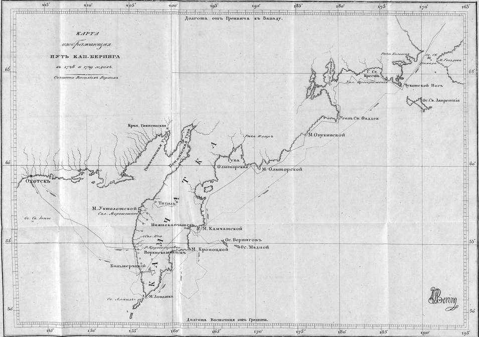
|
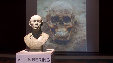
Vitus Bering — Grim Exhibit
Bering was exhumed
simply because no one knew how he looked
like.
Horsens Museum
Vitus Bering 1681-1741
In 1724, Russia's
 Peter the Great gave Danish explorer
Vitus Jonassen Bering
the assignment of a lifetime.
Peter the Great gave Danish explorer
Vitus Jonassen Bering
the assignment of a lifetime.
Bering's task was to discover
whether
Asia and America had a land connection. Why was that of
interest? Possible new trade routes and territorial expansion
for Russia.
|
|
Background Story
to the Image Above
Modern Danish sentiment
judged it unsatisfactory that nobody knew the likeness of their hero Vitus Bering.
A
well recognized painting, thought to have
featured the explorer, turned out to be
Bering's uncle, also called Vitus Bering.
There wasn't an
image of the man. How
was this possible?
And what to do? |
Recovering Bering
On August 1st, 1991, a Soviet-Danish group of archaeologists
and journalists arrived on Bering Island
and, the very next day, begun excavating Vitus Bering's remains, along with
the remains of five of Bering's fellow sailors.
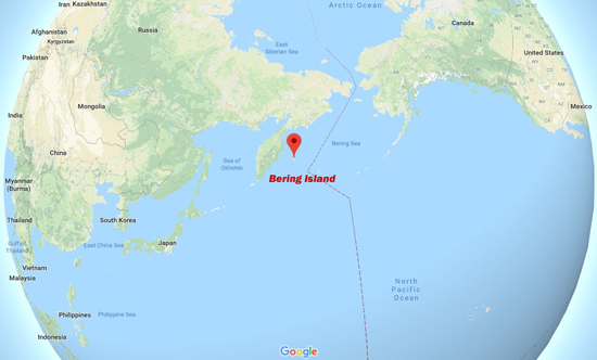
Map Location Bering Island
Google Maps
"We knew where the
cabins they had built lay, and we had the expectation that the
graves were nearby, but we did not know exactly where they
were," remembers Danish archaeologist
Orla Madsen, one of the ten Danes that were
part of the excavation team that counted 30 people in
total.
"Shortly
thereafter we found the first bones [...] exactly where we were trying to find the graves. It was the hole-in-one," Madsen says.
Another Dane, Ole Schioerring, reflects on the momentous
occasion, "It was a day you will always remember."
This was August 8,
1991. But how could they be so sure that these were the remains of Vitus Bering? According to diaries,
Bering was the only one of the six who was buried in a wooden coffin.
There were no trees on the island. "His makeshift coffin was
put together out of driftwood and wreckage from his ship,
his corpse wrapped in canvas from its sails," Schioerring
said.
Their findings were brought to
Moscow for examination, after which
Victor Zvyaigin, a forensic pathologist,
went to work. He reconstructed Vitus Bering's head via educated guess.
Why now, why in 1991?
It had been 250 years
since Vitus Bering's death.
Appropriately, all remains were re-buried on
Bering Island.
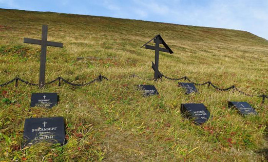
Gravestones for Bering's
Crew Members
Orla Madsen, formerly Horsens
Museum
The Map of the
World in Vitus' Days
Sometimes we take the accuracy
of our
maps for granted. So
let's suppose it's the year 1745, four years after Vitus
Bering had died. When we pull out a map, what do we see?
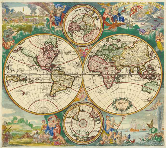
World Map From
Circa 1745
Nova Totius Terrarum
Orbis Tabula by the cartographer
Frederick de Wit
We think that California is an island, and we know about
Australia and New Zealand, but aren't exactly sure about
their coastlines.
Let's zoom in on
our vast cluelessness that is the space between Russia and
North America:
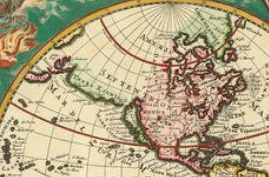
White Space of Ignorance
Cartographers updated their maps based on new geographical discoveries. As illustrated with this map, there was sometimes
a significant delay between discovery and map update at the map maker's office.
However, land grabbing and exploiting usually suffers no
such delay. As soon as the surviving members of Bering's
outfit arrived back home and told their tale, Russians quickly
packed their bags and were on their way.
In fact, Cook wrote of his Third Voyage in
1778:
There are Russians on all the principal Islands between this
and Kamtschatka, for the sole purpose of furing, and the
first and great object is the Sea Beaver or Otter … I never
thought to ask how long it was since they got a footing on
Oonalaska and the neighbouring isles, but to judge from the
great subjection the Natives are under, it must have been
some time.
And while we're trying to understand what it
was like in those days, what were the chances in those days that you could read?
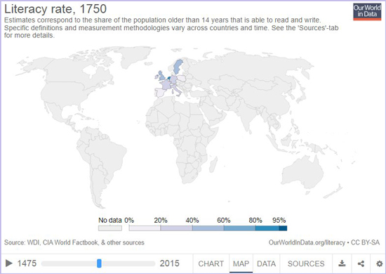
This is an awesome tool by
Literacy Throughout History
Back to Vitus.
Was Vitus Bering the
First European to Explore Bering Strait?
Nope. In 1648, Russian explorer
Semyon Ivanovich Dezhnyov (also
spelled Dezhnev) had already sailed through what would
become today's Bering Strait. Unfortunately, his discoveries
and map drawings (compiled, submitted, read, and
archived in 1655 in Yakutsk) didn't get much attention at the time.
Posterity at least gave him
Cape Dezhnyov. Here is the map:
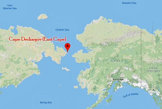
Cape Dezhnyov
(East Cape)
Google Map
Incidentally, a member of Bering's Second Kamchatka
Expedition, the German historian
Gerhard Friedrich
Mueller, was also the man who later
unearthed Dezhnev's reports in Yakutsk.
In 1719, the surveyors Ivan
Evreinof (Evreinoff/Evreinov) and
Fedor Lushin (Luzhin) were sent by Peter the Great to
"determine whether Asia and America are united." After
exploring Kamchatka
and the Kurile Islands, they were back in St.
Petersburg in 1722/1723.
In 1728, eighty years after
Deshnev, Bering sailed through the Strait while on his
First Expedition.
In 1730,
Mikhail S. Gvozdev and
Ivan Fedorov went on their expedition that, in
1732, had them sailing through Bering Strait. This
expedition also made landfall around what would later be
named Cape Prince of Wales, Alaska.
In 1733, Bering went on his
Second Expedition, but he did not enter Bering Strait.
Instead, he sailed into the Gulf of Alaska (see map below.)
In August 1778, Captain James Cook
on his Third Voyage, went up Bering Strait further north
than any other explorer before (70°44' N).
So, quick recap:
Who Sailed
Through Bering Strait and When ?
| 1648 |
|
Deshnev and
Popov |
 |
First
official explorers through Bering
Strait, yet no credits |
| |
|
|
|
|
| 1719 |
|
Luzhin and
Evreinov
(attempt) |
 |
They
tried but didn't make it to Bering Strait, but
they did map the Kurile Islands. |
| |
|
|
|
|
| 1728 |
|
Bering |
|
Sailed
through Bering Strait as part of his First Expedition,
but didn't see the American coast |
| |
|
|
|
|
| 1732 |
|
Gvozdev and
Fedorov |
|
Through
Bering Strait and made landfall on
American soil. |
| |
|
|
|
|
| 1778 |
|
Cook |
|
Of all the explorers so far, Cook
made it to the northernmost
latitude. |
Back to Vitus:
Bering's Life in
a Nutshell
Bering was born on August 12, 1681, at
Horsens, Denmark. Here is the link to the
Horsens Museum, which
features a permanent Bering exposition.
:: Bering's Family
His father, a customs inspector
and warden in the Lutheran Church, was
Jonas Svendsen Halmstad who lived 1637-1719/1720.
His mother was
Anne Pedersdatter Bering.
She had two younger sisters.
From his previous marriage with
his first wife Lisbeth Bendtsdatter, Jonas brought three
children into this marriage with Anne:
Anna Cathrine, Jonas, and
Svend.
With Anne, his second wife, he
had two sons: Vitus and
Jorgen Christoffer Blymester.
Ten years later, on October 8,
1713, Vitus married Anna Christina Pülse (Puelse)in Vyborg
(in today's Russia), which had been taken from Sweden in 1710.
Anna's family was a
German-speaking Swedish family. At the time
of his wedding, Bering was captain-lieutenant. They had nine children, only
four survived childhood.
:: Early Years
Vitus' half brothers Jonas and Svend attended the University of
Copenhagen, Denmark's oldest university, founded in 1479.
Jonas became a court clerk, and
Svend studied theology. Svend ran into legal trouble,
participated in a riot, was arrested, and his sentence was
commuted to serving 15 years as customs collector in
Tranquebar, modern day Tharangampad, India.
Young Vitus decided to come
with, earning his fare as ship's boy, and the two took a
Dutch vessel direction India in 1696 with a Dutch outfit.
Tranquebar had
been a Danish colony since 1620. Here is
more from the Danish National Museum on Tranquebar.
Back in the days it had about
3,000 inhabitants. Today around 7,000.
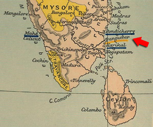
Tranquebar Map Location
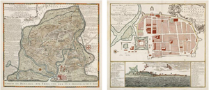
Tranquebar Maps by National Museum of
Denmark
:: On Russian
Payroll
When Vitus came back home to
Europe from
India in 1703, Europe
was at war. This was the
Great Northern War,
which was fought 1700-1721.
The same year, 1703, still in
Amsterdam, he ran into Niels Olsen,
25 years his senior, a fellow from Norway who had moved to
Amsterdam, had changed his name to Cornelius Cruys, and
served as admiral in the Russian Navy.
This encounter led to Bering's employment by the Russian Navy.
And thus right away, Vitus became a participant in
Russia's war against Sweden (Denmark was one of Russia's
allies in this war.) However, it seems that Vitus didn't see direct battle.
In a surprising twist of our
story, Vitus uncharacteristically opted
for voluntary retirement in 1724.
But his retirement lasted only a
few months, after which, probably out of a mixture of
boredom and no money, he asked to return to active duty.
Request granted and Voila, Bering's second Russian Navy
career was launched.
And speaking of the Russian
Navy:
At the time, the Russian Navy
was very appreciative of capable Scandinavian sailors.
Tsar Peter the Great, a great naval enthusiast himself,
especially welcomed the
leading shipbuilders of his time, who came mainly from
Denmark and Norway.
One of the Tsar's projects was a map update of his empire,
especially with an emphasis on the question whether Asia and
America are connected.
In 1719, Peter had sent
his surveyors Evreinof (Evreinoff/Evreinov) and
Lushin to find out more, but
their outfit only made it to
the Kuril Islands, which although impressive did not answer
Peter's question.
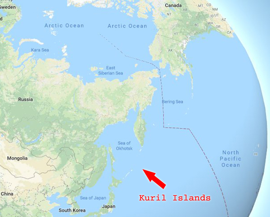
Map Location of the Kuril Islands
The Kuril Islands are an 750 miles (1,200 km)
long island chain, consisting of 56 islands that run from
the southern tip of the Kamchatka Peninsula (Russia)
to the northeastern corner of Hokkaido island (Japan)
and separates the Sea of Okhotsk from the Pacific Ocean.
Google Map
Enter Vitus.
:: Bering's First Expedition 1725-1730
Also called the
First
Kamchatka Expedition
or Bering's
First
Artic Expedition
Evreinov and Luzhin returned to
St. Petersburg in 1722 or 1723.
Shortly after, on January 3,
1725 (December 23, 1724
Old Style) Russia's
Tsar
Peter the Great
prepared the following orders:
I. At Kamchatka or somewhere else two decked
boats are to be built.
II. With these you are to sail northward
along the coast, and as the end of the coast
is not known, this land is undoubtedly
America.
III. For this reason you are to inquire
where the American coast begins, and go to
some European colony; and when European
ships are seen you are to ask what the coast
is called, note it down, make a landing,
obtain reliable information, and then, after
having charted the coast, return.
This is translated from the
original Russian, from the book Vitus Bering: the
Discoverer of Bering Strait by Peter Lauridsen,
member of the Council of the Royal Danish Geographical
Society.
You can read it as a
Project
Gutenberg EBook
The date of these instructions
is sometimes cited as January 6, 1725. We can't be sure
which date is correct, because Peter's original document
has not been preserved.
General-Admiral Feodor
Matveyevich, Count Apraksin (1671-1728)
February 4, 1725
(January 24, 1725
Old Style) |
|
In
the interest of the expedition, 27
of Bering's 33 men set off. With
them 25 wagonloads of materials.
Bering himself stayed behind in St.
Petersburg to receive their official
instructions. |
| |
|
|
February 8, 1725
(January 28, 1725
Old Style) |
|
Peter
the Great died. |
| |
|
|
February 16, 1725
(February 5, 1725
Old Style) |
|
Vitus
Bering received Peter's instructions, which were handed to
him by Peter's widow
Catherine I. Bering
then left St. Petersburg with the
rest of his team. The expedition was
on its way.
Bering's two right hands were his
fellow Dane
Martin Spangberg (Spangsberg,
or Martin Pedersen Spangsberg or
Morten Spangberg, or martyn
Petrovich) and the Russian
Aleksey Ilich Chirikov. Both men
took part in the First and the
Second Expedition.
Of course before anything could
be explored, one had to get to the
edge of what was already known on a
map. The journey from St. Petersburg
to Kamchatka was in and of itself a
formidable challenge that took three
years. Including equipment and
supplies.
This trip went via Tobolsk,
which Google maps calculates this
route as 40 hours by car. Roughly
1,800 miles. |
| |
|
|
May
26, 1725
(May 15, 1725
Old Style) |
|
They
left Tobolsk. |
| |
|
|
|
July
1727 |
|
They arrived at
Okhotsk, at the edge of Siberia. They settled in for the
winter. |
| |
|
|
July
14, 1727
(July 3, 1727
Old Style) |
|
Lieutenant Chirikov, coming from
Yakutsk, joined. He brought with him
an enormous amount of flour. |
| |
|
|
September 1, 1727
(August 21, 1727
Old Style) |
|
On to
Bolsheretsk, a post founded in 1702.
By 1727 it had still just 14 Russian
houses. |
| |
|
|
|
March
1728 |
|
They crossed the
Sea of Okhotsk to arrive on the Kamchatka Peninsula.
Once at the edge in Siberia, he
built a ship for his crossing to Kamchatka.
So far Vitus had enough
challenges with men who had deserted and horses who had died
etc. But the real challenge was ahead. |
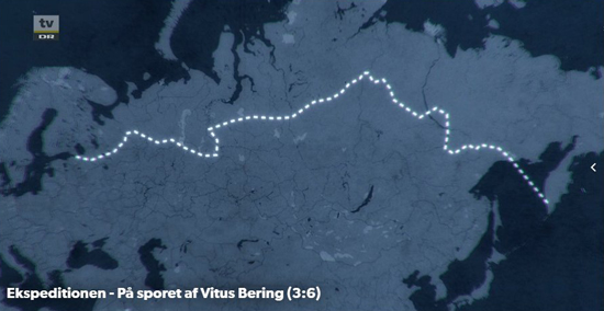
From
St. Petersburg to the Kamchatka Peninsula
On the Trail of Vitus Bering
/
Danish Broadcasting Corporation
Once arrived on the west coast
of the Kamchatka Peninsula, they trekked overland to
Kamchatka's east coast.
April 15, 1728
(April 4, 1728
Old Style) |
|
At
Lower Kamchatka Post, work begun on
building the ship, the Saint Gabriel.
Timber had been hauled by dogs, and
tar was not available, so they had
to make it themselves, which they
did out of Larch trees. |
| |
|
|
July 21, 1728
(July 10, 1728
Old Style) |
|
The
ship was complete. |
| |
|
|
July 25, 1728
(July 14, 1728
Old Style) |
|
Having
on board "enough provisions to last
40 men a year," the expedition
"sailed from the mouth of the
Kamchatka River out to sea an
followed the course laid down by the
instructions of His Imperial Majesty
Peter the Great."
The
actual expedition was on its way. |
And here is a picture of the Gabriel:
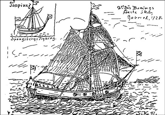
Bering's ship
The Gabriel as drawn by Martin Spangsberg
Kingo Jacobsen, N. (1992). Vitus Bering. Geografisk Tidsskrift,
92.
August 21, 1728 (August 10, 1728
Old Style) - Discovery of
St. Lawrence Island. They found a few huts, but no people.
August 26, 1728 (August 15, 1728
Old Style) from the logbook:
By August 15 we came to
latitude 67° 18' N and turned back because the coast did
not extend farther north and no land was near the Chukchi or
East Cape and therefore it seemed to me that the
instructions of His Imperial Majesty of illustrious and
immortal memory had been carried out.
Had we gone on and met with
unfavorable winds we might have been prevented from
returning to Kamchatka that season, and to have wintered
where we were would not have been wise because there was no
wood of any kind and the native population does as it
pleases, is not under Russian control, and has nothing to do
with the Russian tribute collectors.
September 13, 1728 (September 2,
1728
Old Style) - They sailed
into the mouth of the Kamchatka River and passed the winter
in the Lower Kamchatka Post.
June 16, 1729 (June 5, 1729
Old Style) - Having
repaired the ship, they left the mouth of the Kamchatka
River.
They circumnavigated and
chartered the southern part of Kamchatka, then sailed to the
mouth of the Bolshaya River, and from there to Okhotsk Post.
They reached the mouth of the
Okhota River on August 3, 1729 (July 23, 1729
Old Style), where
Bering handed over the ship.
On to Yudoma Cross via horseback, from there by boat down
the Aldan River, back onto horseback direction Yakutsk.
Covering the distance from from Okhotsk to Yakutsk took from
August 9, 1729 (July 29, 1729
Old Style) to September
14, 1729 (September 3, 1729
Old Style).
On September 21, 1729 (September
10, 1729
Old Style) via boat up
the Lena River. Blocked by ice on October 12, 1729 (October
1, 1729
Old Style), therefore
forced to spend a part of the autumn in the village of
Peleduye.
Onwards on November 9, 1729 (October 29, 1729
Old Style). Arriving at
Tobolsk on Jamuary 21, 1730 (January 10, 1730
Old Style).
Onwards on February 5, 1730 (January 25, 1730
Old Style).
On March 12, 1730 (March 1, 1730
Old Style) Vitus was
back in St. Petersburg.
Hence Bering's first official
Arctic expedition
set out from the Kamchatka peninsula, and led him through
what is today Bering Strait, into the Arctic Ocean.
Bering's First Kamchatka Expedition
Overland from St. Petersburg to
Kamchatka took 3 years alone
Horsens Museum
Here you can read the
daily logs from Bering's First
Expedition as PDF (in Russian)
Also included are "brief biographical sketches of
Bering and his senior officers from the first voyage."
And this is Bering's own map
from his First Expedition. Source: above mentioned PDF.
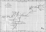
Bering's map
from his First Expedition
Click to enlarge
Outcome of the First Expedition:
Bering sailed through Bering
Strait but had to content with bad weather which made
sighting the American coast impossible. However, he made an
educated guess that Asia and America are not connected.
What made him think that?
"Sea depths, drift timber, birds
etc. had convinced him of the proximity of the mainland."
And as a little nugget for surfer dudes, here's Bering's
comment after his first but before his second expedition:
"According to my observation the waves of eastern Kamchatka
are smaller than in other seas... These signs indicate that
America or some other land on this side of it, is not far
from Kamchatka."
Peter Lauridsen "Vitus Bering: The Discoverer of Bering Strait
" 1889
True or not, you can check it yourself, see here:
A small band of enthusiasts has helped the remote region of
Kamchatka become a year-round mecca for surfers
Turned out, his employers wanted
something a little bit more solid. Like reaching American
soil. So he had to go again.
See map below.
:: Bering's Second Expedition 1733-1741
Also called the
Second
Kamchatka Expedition or the
Great Northern Expedition.
To be exact, the Great Northern
Expedition is the umbrella term for several voyages made by
several Russian teams from 1733 to 1743. Bering's
Second Expedition was one of them.
While Russia was now ruled by
Tsarina Anna Ivanova,
Bering embarked on his second Arctic expedition, starting
again from the Kamchatka Peninsula, then into the Gulf of Alaska
and back along the Aleutians. He shipwrecked off Bering
Island, where he died on December 19, 1741.
As many as 600 men were
involved. Spanberg again was the second in command.
Here are his two ships. The St. Peter and St. Paul launched
in June 1740.
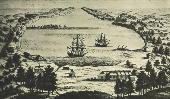
And here is the map:
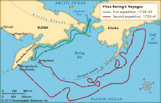
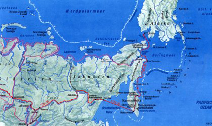
Map of Vitus
Bering's Voyages
Illustrating: First Expedition 1728-1730 / Second Expedition
1733-1741
Copyright Encyclopaedia
Britannica
Here is more about
Ancient Beringia
And here is a map of Ancient Beringia:
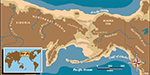
Ancient Beringia
Click to enlarge
And maybe:
Alaska Purchase 1867
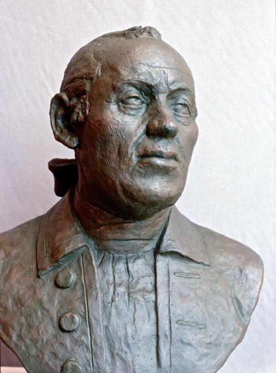
Russian forensics have tried to restore Vitus Bering's face.
It can be seen today at Horsens Museum. (Photo: Orla Madsen)
Sources
Frank Alfred
Golder's
Bering's Voyages - An Account of the Efforts of the Russians to Determine the Relation of Asia and America, Volume I and
Volume II
(1922)
More History
|