History for the Relaxed Historian
HISTORY FOR THE RELAXED HISTORIAN

PEOPLE IN HISTORY          WARS, BATTLES AND REVOLUTIONS          MAP ARCHIVE          FAMOUS SPEECHES


GOVERNMENTS IN HISTORY          HISTORIC DOCUMENTS          HISTORIC PLACES AND LOCATIONS          ALL-TIME RECORDS IN HISTORY


SOURCE TEXT          SOURCE DOCUMENTS          HISTORY DICTIONARY          TIMELINES          ARCHAEOLOGICAL RECORDS


HOME   -   HISTORY MAPS   -   EXPANSION OF THE UNITED STATES 1783-1907


Reference Maps on the American Revolution 1775-1783

Map of the United States: Battle Sites 1689-1945

Map of the British Colonies in North America 1763-1775

Map of the Thirteen Colonies at the End of the Colonial Period

Map of the North American Colonies (Colbeck)

Map of the American Colonies: Population Density 1775

Map of North America before the War of American Independence and North America After the War

Map of the War of Independence and the War of 1812-1814

Map of the Campaigns of the American Revolution 1775-1783 (USMA)

Map of the Campaigns of the American Revolution 1775-1781 (Shepherd)

Map of the American Revolution: Campaigns 1775-1776

Map of the Battles of Lexington and Concord - April 19, 1775

Map of the Siege of Boston, April 20, 1775 - March 17, 1776

Map of the Battle of Bunker Hill - June 17, 1775

Map of the Battle of Bunker Hill - June 17, 1775: First British Attack

Map of the Battle of Bunker Hill - June 17, 1775: Second British Attack

Map of the Battle of Bunker Hill - June 17, 1775: Final British Attack

Map of the Battle of Long Island - August 27, 1776

Map of the Battle of Harlem Heights - September 16, 1776

Map of the American Revolution: Fall 1776

Map of the Battle of Valcour Island - October 11, 1776

Map of the Battles of Trenton and Princeton 1776-7

Map of the Battle of Trenton - December 26, 1776

Map of the Battle of Princeton - January 3, 1777

Map of the Mohawk River Valley 1775/1777

Map of the Campaign of 1777

Map of Burgoyne's Expedition June-October 1777

Map of the Original Plan for the British Invasion of New York — June-October 1777

Map of the Battle of Fort Ticonderoga - July 2-6, 1777

Map of the Saratoga Campaign: Ticonderoga to Freeman's Farm, July 5 - September 19, 1777

Map of the Battle of the Brandywine - September 11, 1777

Map of the Battle of the Brandywine - September 11, 1777 - Overview

Map of the Battle of Saratoga 1777 (Creasy)

Map of the First Battle of Saratoga - September 19, 1777

Map of the First Battle of Saratoga: Initial Dispositions - September 19, 1777

Map of the First Battle of Saratoga: Situation at 1300 Hours - September 19, 1777

Map of the First Battle of Saratoga: Situation at 1500 Hours - September 19, 1777

Map of the First Battle of Saratoga: Situation at 1700 Hours - September 19, 1777

Map of the Battle of Germantown - October 4, 1777

Map of the Battle of Fort Montgomery and Fort Clinton: Prelude October 5-6, 1777

Map of the Battle of Fort Montgomery and Fort Clinton - October 6, 1777

Map of the Second Battle of Saratoga: Initial Dispositions - October 7, 1777

Map of the Second Battle of Saratoga - October 7, 1777

Map of Burgoyne's Camp  - October 11-17, 1777

Map of the American Revolution: May-July 1778

Map of the American Revolution: Campaigns 1778-1781

Map of the Battle of Monmouth - June 28, 1778

Map of the Battle of Stony Point - July 16, 1779

Map of the Battle of Stony Point: Attack - July 16, 1779

Map of the Campaigns 1780

Map of the Siege of Charleston 1780

Map of the Battle of Camden - August 16, 1780

Map of the Defenses at West Point 1780

Map of the Hudson Highlands 1780

Map of the Operations in the South 1780

Map of the Operations in the South 1781

Map of the Operations in Virginia 1781

Map of the Battle of Cowpens - January 17, 1781

Map of the Battle of Cowpens: British Attack - January 17, 1781

Map of the Battle of Cowpens: American Counterattack - January 17, 1781

Map of the Battle of Guilford Courthouse - March 15, 1781

Map of the Battle of Eutaw Springs - September 8, 1781

Map of the March to Yorktown 1781

Map of the Siege of Yorktown - September 28-October 19, 1781

Fourteen History Maps of the United States: Territorial Growth 1775-1970

Slavery and Emancipation in the United States 1777-1865

Map of the United States 1783-1803

Three Maps of the Expansion of the United States 1783-1854

Map of the Expansion of the United States 1783-1907


Reference Maps on the Mexican-American War 1846-1848

Map of the United States: Battle Sites 1689-1945

Map of Mexico and Texas 1845-1848

Map of the Campaigns of the Mexican War 1846-1847

Map of the Campaign Routes - War between the United States and Mexico 1846-1847

Map of Stephen Kearny's Campaign in New Mexico and A.W. Doniphan's Campaign in Chihuahua

Map of Taylor's Campaign, March 1846 - February 1847

Map of the Battle of Palo Alto - May 8, 1846

Map of the Battle of Resaca de la Palma - May 9, 1846


Reference Maps on the Aftermath of the Mexican-American War 1846-1848

Fourteen Maps of the United States: Territorial Growth 1775-1970

Three Maps of the United States: Expansion 1783-1854

Map of the Expansion of the United States 1783-1907

Four Maps of the Organization of Territories in the United States Since 1803

Map of the United States: Expansion 1836-1853

Map of Mexican Territories Annexed in 1845 and Territories Lost by Mexico in 1848-1853


Map Description
Historical Map of the Expansion of the United States 1783-1907

Illustrating

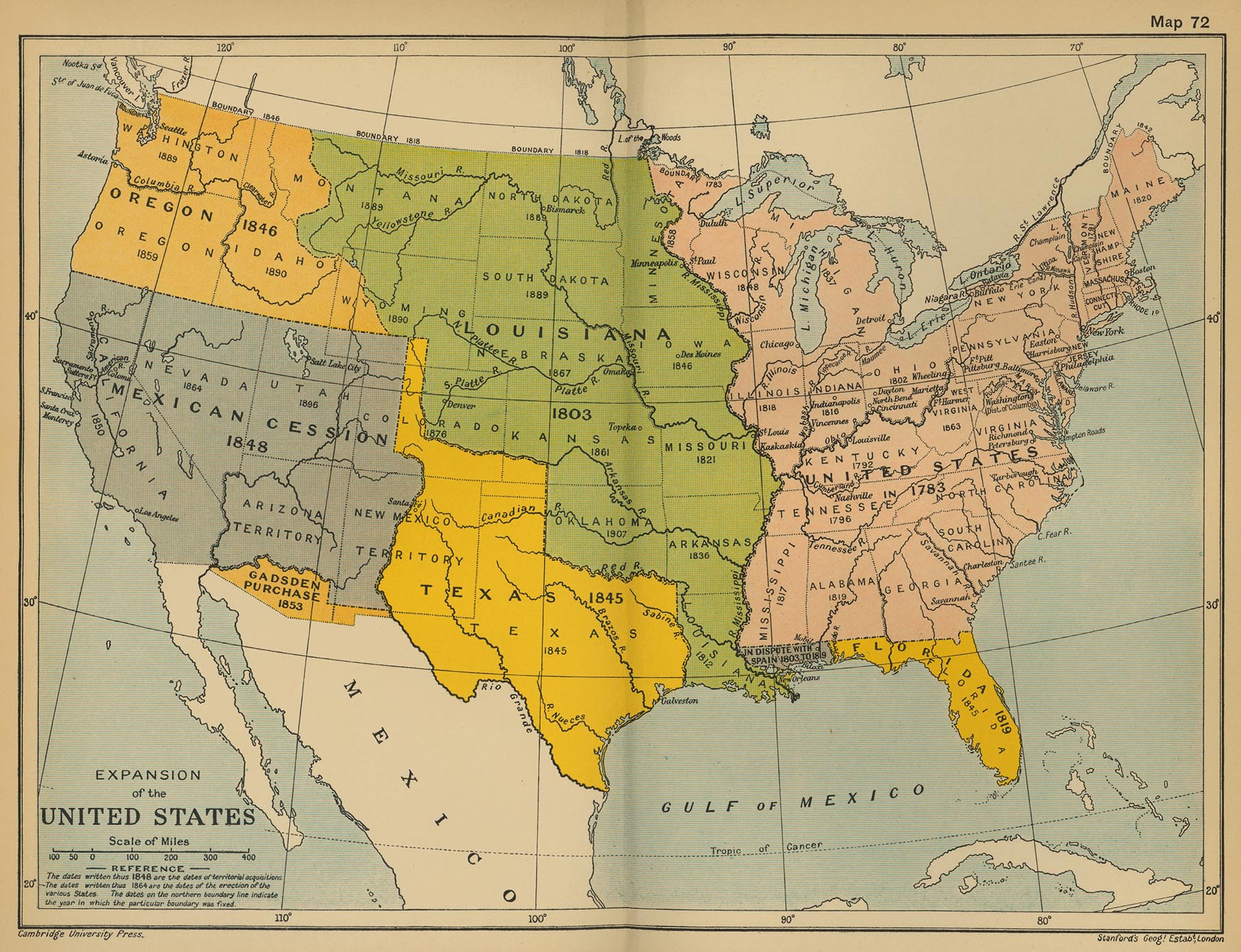
- The United States in 1783 and the dates of territorial acquisitions, i.e. Louisiana 1803
   (see
Louisiana Purchase 1803), Florida 1819 (see Adams-Onis Treaty),
   Texas 1845, Oregon 1846, Mexican Cession 1848 (see
Treaty of Guadalupe Hidalgo),
  
Gadsden Purchase 1853

- The dates of the erection of the various States, i.e. statehood of Vermont 1791,
   Kentucky 1792, Tennessee 1796, Ohio 1802, Louisiana 1812, Indiana 1816, Mississippi 1817,
   Illinois 1818, Alabama 1819, Maine 1820, Missouri 1821, Arkansas 1836, Michigan 1837,
   Florida 1845, Texas 1845, Iowa 1846, Wisconsin 1848, California 1850, Minnesota 1858,
   Oregon 1859, Kansas 1861, West Virginia 1863, Nevada 1864, Nebraska 1867, Colorado 1876,
   North Dakota 1889, South Dakota 1889, Montana 1889, Washington 1889, Idaho 1890,
   Wyoming 1890, Utah 1896, Oklahoma 1907

- The dates on the northern boundary line indicate the year in which the particular
   boundary was fixed.


Credits
University of Texas at Austin. From the Cambridge Modern History Atlas, 1912.


Related Links
About the Texas Revolution     About the Mexican-American War  

 
Map of the Expansion of the United States 1783-1907


More History


People in History

Historic People - Main

People in History A - C

People in History D - F

People in History G - I

People in History J - M

People in History N - Q

People in History R - Z

Royal Families

Tribes & Peoples

Explorers, Scientists & Inventors

Musicians, Painters & Artists

Poets, Writers & Philosophers

First Ladies

Native Americans & The Wild West

Troublemakers

Historians

Archaeologists


Wars, Battles & Revolutions

Wars & Revolutions A

Wars & Revolutions B - E

Wars & Revolutions F - G

Wars & Revolutions H - J

Wars & Revolutions K - O

Wars & Revolutions P - R

Wars & Revolutions S - Z

Wars & Revolutions Chronological

Battles A - C

Battles D - L

Battles M - P

Battles Q - Z

Battles Ancient Times - 1499

Battles 1500 - 1799

Battles 1800 - Today


Miscellaneous


History Dictionary A - F

History Dictionary G - Z

Source Text - By Title

Source Text - By Author

Historic Documents A - Z

Historic Documents Chronological

History News

Research

Downloads


Bored?

Castles and Palaces


Kids & History

Browse

About Us

Write Me


Sitemaps

Sitemap 01   Sitemap 02   Sitemap 03    Sitemap 04   Sitemap 05   Sitemap 06  
Sitemap 07   Sitemap 08   Sitemap 09    Sitemap 10   Sitemap 11   Sitemap 12
Sitemap 13   Sitemap 14   Sitemap 15    Sitemap 16   Sitemap 17   Sitemap 18
Sitemap 19   Sitemap 20   Sitemap 21    Sitemap 22   Sitemap 23


Site Search


HISTORY IN A NUTSHELL


© 2016 Emerson Kent