History for the Relaxed Historian
HISTORY FOR THE RELAXED HISTORIAN

PEOPLE IN HISTORY          WARS, BATTLES AND REVOLUTIONS          MAP ARCHIVE          FAMOUS SPEECHES


GOVERNMENTS IN HISTORY          HISTORIC DOCUMENTS          HISTORIC PLACES AND LOCATIONS          ALL-TIME RECORDS IN HISTORY


SOURCE TEXT          SOURCE DOCUMENTS          HISTORY DICTIONARY          TIMELINES          ARCHAEOLOGICAL RECORDS


HOME   -   HISTORY MAPS   -   United States 1777-1865: Slavery and Emancipation


Reference Maps on the American Revolution 1775-1783

Map of the United States: Battle Sites 1689-1945

Map of the British Colonies in North America 1763-1775

Map of the Thirteen Colonies at the End of the Colonial Period

Map of the North American Colonies (Colbeck)

Map of the American Colonies: Population Density 1775

Map of North America before the War of American Independence and North America After the War

Map of the War of Independence and the War of 1812-1814

Map of the Campaigns of the American Revolution 1775-1783 (USMA)

Map of the Campaigns of the American Revolution 1775-1781 (Shepherd)

Map of the American Revolution: Campaigns 1775-1776

Map of the Battles of Lexington and Concord - April 19, 1775

Map of the Siege of Boston, April 20, 1775 - March 17, 1776

Map of the Battle of Bunker Hill - June 17, 1775

Map of the Battle of Bunker Hill - June 17, 1775: First British Attack

Map of the Battle of Bunker Hill - June 17, 1775: Second British Attack

Map of the Battle of Bunker Hill - June 17, 1775: Final British Attack

Map of the Battle of Long Island - August 27, 1776

Map of the Battle of Harlem Heights - September 16, 1776

Map of the American Revolution: Fall 1776

Map of the Battle of Valcour Island - October 11, 1776

Map of the Battles of Trenton and Princeton 1776-7

Map of the Battle of Trenton - December 26, 1776

Map of the Battle of Princeton - January 3, 1777

Map of the Mohawk River Valley 1775/1777

Map of the Campaign of 1777

Map of Burgoyne's Expedition June-October 1777

Map of the Original Plan for the British Invasion of New York — June-October 1777

Map of the Battle of Fort Ticonderoga - July 2-6, 1777

Map of the Saratoga Campaign: Ticonderoga to Freeman's Farm, July 5 - September 19, 1777

Map of the Battle of the Brandywine - September 11, 1777

Map of the Battle of the Brandywine - September 11, 1777 - Overview

Map of the Battle of Saratoga 1777 (Creasy)

Map of the First Battle of Saratoga - September 19, 1777

Map of the First Battle of Saratoga: Initial Dispositions - September 19, 1777

Map of the First Battle of Saratoga: Situation at 1300 Hours - September 19, 1777

Map of the First Battle of Saratoga: Situation at 1500 Hours - September 19, 1777

Map of the First Battle of Saratoga: Situation at 1700 Hours - September 19, 1777

Map of the Battle of Germantown - October 4, 1777

Map of the Battle of Fort Montgomery and Fort Clinton: Prelude October 5-6, 1777

Map of the Battle of Fort Montgomery and Fort Clinton - October 6, 1777

Map of the Second Battle of Saratoga: Initial Dispositions - October 7, 1777

Map of the Second Battle of Saratoga - October 7, 1777

Map of Burgoyne's Camp  - October 11-17, 1777

Map of the American Revolution: May-July 1778

Map of the American Revolution: Campaigns 1778-1781

Map of the Battle of Monmouth - June 28, 1778

Map of the Battle of Stony Point - July 16, 1779

Map of the Battle of Stony Point: Attack - July 16, 1779

Map of the Campaigns 1780

Map of the Siege of Charleston 1780

Map of the Battle of Camden - August 16, 1780

Map of the Defenses at West Point 1780

Map of the Hudson Highlands 1780

Map of the Operations in the South 1780

Map of the Operations in the South 1781

Map of the Operations in Virginia 1781

Map of the Battle of Cowpens - January 17, 1781

Map of the Battle of Cowpens: British Attack - January 17, 1781

Map of the Battle of Cowpens: American Counterattack - January 17, 1781

Map of the Battle of Guilford Courthouse - March 15, 1781

Map of the Battle of Eutaw Springs - September 8, 1781

Map of the March to Yorktown 1781

Map of the Siege of Yorktown - September 28-October 19, 1781

Fourteen History Maps of the United States: Territorial Growth 1775-1970

Slavery and Emancipation in the United States 1777-1865

Map of the United States 1783-1803

Three Maps of the Expansion of the United States 1783-1854

Map of the Expansion of the United States 1783-1907


Related

Speech: The Hypocrisy of American Slavery - Frederick Douglass on July 5, 1852
Speech: The Hypocrisy of American Slavery
Frederick Douglass on July 5, 1852


Speech: I've Seen the Promised Land - Martin Luther King on April 3, 1968
Speech: I've Seen the Promised Land
Martin Luther King on April 3, 1968


Map Description
Historical Map of Slavery and Emancipation in the United States, 1777-1865.

Inset: The Region South of the Great Lakes.


Illustrating:

- Area of the Original Thirteen States

- Slave Free before 1850


- Areas forming part of the Union before 1783, but not admitted as States until later

- Slave States (except Arkansas) admitted, 1792-1845

- Slave State by annexation, 1845


- Free territory by the Ordinance of 1787 (held by the courts not to free pre-existent slaves) supplemented by territorial
  Acts of Congress and by State constitutions

- Free territory by Act of Congress annexing Texas


- Free territory by the
Missouri Compromise, 1820

- Free State admitted from the area subject to the Missouri Compromise

- Slave State admitted from the area subject to the Missouri Compromise

- Free by the Missouri Compromise; slave by addition to Missouri in 1836

- Open to slavery by the Missouri Compromise

- Free by the Missouri Compromise; but opened to slavery by the Compromise of 1850

- Territory acquired from Mexico in 1845; free by Mexican law, but opened to slavery by the Compromise of 1850


- Free State admitted from the territory acquired from Mexico

- Free territory by act of organization, 1848


The areas opened to slavery under the principle of the
Kansas-Nebraska Act of 1854 are indicated by the red lettering.
The territorial organization shown in the map is that of 1854.

Further illustrating the dates of immediate abolition, or the beginnings of gradual emancipation, by State action before 1861;
and the dates of immediate abolition by State or national action between 1861 and 1865.

No reference is made to the Dred Scott dicta of 1857, or to the Emancipation Proclamation of 1863; because, legally,
the one did not authorize the introduction of slavery into the Territories any more than the other effected the abolition of
slavery in the Southern States.

- Land and Sea routes of the slave trade

- "Underground" routes of fugitive slaves (land and water)


The area east of the present State of Oregon formed part of Washington Territory in 1862. The names printed in thin capitals
are those of States admitted subsequent to 1854, and of the two Territories still remaining.


Balancing in the admission of free and slave States before 1850


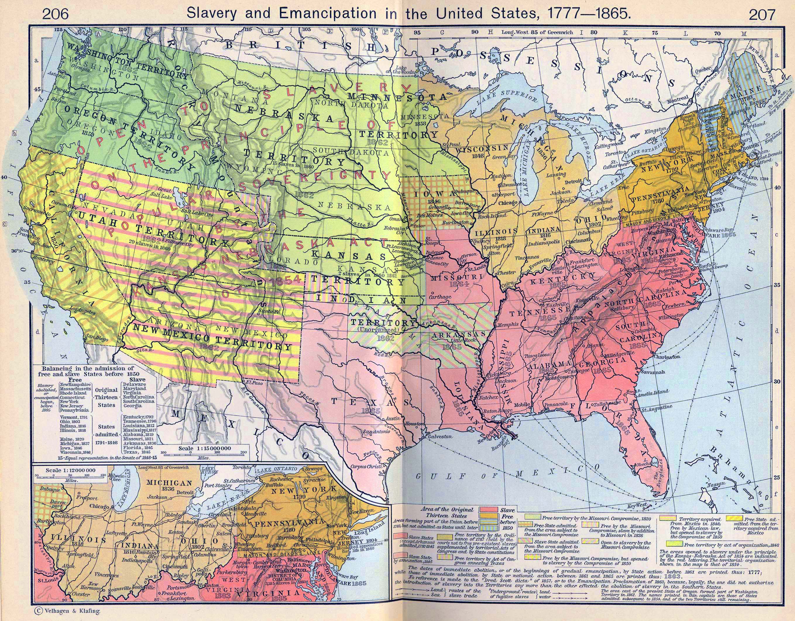
Slavery abolished, or emancipation begun, before 1805
Free

New Hampshire
Massachusetts
Rhode Island
Connecticut
New York
New Jersey
Pennsylvania

Vermont, 1791
Ohio, 1803
Indiana, 1816
Illinois, 1818

Maine, 1820
Michigan, 1837
Iowa, 1846
Wisconsin, 1848


Original
Thirteen
States


States
admitted
1791-1848
 

Slave

Delaware
Maryland
Virginia
North Carolina
South Carolina
Georgia


Kentucky, 1792
Tennessee, 1796
Louisiana, 1812
Mississippi, 1817
Alabama, 1819
Missouri, 1821
Arkansas, 1836
Florida, 1845
Texas, 1845


- Equal representation in the Senate of 1848


Credits
University of Texas at Austin. Historical Atlas by William Shepherd (1911).


Related Links
About the American Revolution


Reference Maps on the Slave Trade

Map of Slavery and Emancipation in the United States 1777-1865

Map of the Slave Population in the United States 1860

World Map: Slave Trade 1400-1900

World Map: Slave Trade 1400-1600

World Map: Slave Trade 1600-1700

World Map: Slave Trade 1700-1800

World Map: Slave Trade 1800-1900

World Map: Slave Trade 1400-1900 - Five Maps

World Map: Slave Trade 1400-1900 - Five Maps (PDF)

European Ports: Slave Trade Traffic 1500-1815


Map of the United States 1777-1865: Slavery and Emancipation


More History


People in History

Historic People - Main

People in History A - C

People in History D - F

People in History G - I

People in History J - M

People in History N - Q

People in History R - Z

Royal Families

Tribes & Peoples

Explorers, Scientists & Inventors

Musicians, Painters & Artists

Poets, Writers & Philosophers

First Ladies

Native Americans & The Wild West

Troublemakers

Historians

Archaeologists


Wars, Battles & Revolutions

Wars & Revolutions A

Wars & Revolutions B - E

Wars & Revolutions F - G

Wars & Revolutions H - J

Wars & Revolutions K - O

Wars & Revolutions P - R

Wars & Revolutions S - Z

Wars & Revolutions Chronological

Battles A - C

Battles D - L

Battles M - P

Battles Q - Z

Battles Ancient Times - 1499

Battles 1500 - 1799

Battles 1800 - Today


Miscellaneous


History Dictionary A - F

History Dictionary G - Z

Source Text - By Title

Source Text - By Author

Historic Documents A - Z

Historic Documents Chronological

History News

Research

Downloads


Bored?

Castles and Palaces


Kids & History

Browse

About Us

Write Me


Sitemaps

Sitemap 01   Sitemap 02   Sitemap 03    Sitemap 04   Sitemap 05   Sitemap 06  
Sitemap 07   Sitemap 08   Sitemap 09    Sitemap 10   Sitemap 11   Sitemap 12
Sitemap 13   Sitemap 14   Sitemap 15    Sitemap 16   Sitemap 17   Sitemap 18
Sitemap 19   Sitemap 20   Sitemap 21    Sitemap 22   Sitemap 23


Site Search


HISTORY IN A NUTSHELL


© 2016 Emerson Kent