PEOPLE IN HISTORY WARS, BATTLES AND REVOLUTIONS MAP ARCHIVE FAMOUS SPEECHES
GOVERNMENTS IN HISTORY HISTORIC DOCUMENTS HISTORIC PLACES AND LOCATIONS ALL-TIME RECORDS IN HISTORY
SOURCE TEXT SOURCE DOCUMENTS HISTORY DICTIONARY TIMELINES ARCHAEOLOGICAL RECORDS
HOME - HISTORY MAPS - Quiberon Bay 1759 and 1795
Reference Maps for the Seven Years' War 1754-1763
World Map: the Struggle for Colonial Dominion 1700-1763 World Map: the Principal Seats of War 1740-1763 Map of Central Europe 1740-1786: Wars of Frederick the Great Map for the Silesian and Seven Years' Wars 1740-1763 Two Maps of the Battle of the Monongahela - July 9, 1755 Map of North Central Europe 1756 Map of the Seven Years War: Frederick's Strategy Map of the Seven Years War: Interior Lines 1757 Map of the Seven Years War: Bohemia 1757 Map of the Seven Years War: Bohemia Withdrawal 1757 Map of the Seven Years War: Saxony and Silesia 1757 Map of the Battle of Prague - May 6, 1757 - Attempted Envelopment Map of the Battle of Prague - May 6, 1757 - Penetration Map of the Battle of Rossbach: Prelude - November 2-4,1757 - Maneuver for Position (USMA) Map of the Battle of Rossbach: The Trap - November 5,1757 (USMA) Map of the Battle of Rossbach - November 5, 1757 (Colbeck) Map of the Battle of Leuthen - December 5, 1757 (Colbeck) Map of the Battle of Leuthen - December 5, 1757 - The Fix (USMA) Map of the Battle of Leuthen - December 5, 1757 - The Shift (USMA) Map of the Battle of Leuthen - December 5, 1757 - The Press (USMA) Map of the Battle of Leuthen - December 5, 1757 - The Kill (USMA) Map of the Battle of Leuthen - December 5, 1757 - Frederick's Deployment (USMA) Map of the Battle of Minden - August 1, 1759 Map of the Siege of Quebec 1759 (Colbeck) Map of the Siege of Quebec 1759 (USMA) Map of the Battle of Quiberon Bay - November 20, 1759 Map of India in the time of Clive 1760 Map of India 1760-1770 Map of India 1760-1858 Map of the West Indies in 1763 Map of British Colonies in North America, 1763-1775
World Map: the Struggle for Colonial Dominion 1700-1763
World Map: the Principal Seats of War 1740-1763
Map of Central Europe 1740-1786: Wars of Frederick the Great
Map for the Silesian and Seven Years' Wars 1740-1763
Two Maps of the Battle of the Monongahela - July 9, 1755
Map of North Central Europe 1756
Map of the Seven Years War: Frederick's Strategy
Map of the Seven Years War: Interior Lines 1757
Map of the Seven Years War: Bohemia 1757
Map of the Seven Years War: Bohemia Withdrawal 1757
Map of the Seven Years War: Saxony and Silesia 1757
Map of the Battle of Prague - May 6, 1757 - Attempted Envelopment
Map of the Battle of Prague - May 6, 1757 - Penetration
Map of the Battle of Rossbach: Prelude - November 2-4,1757 - Maneuver for Position (USMA)
Map of the Battle of Rossbach: The Trap - November 5,1757 (USMA)
Map of the Battle of Rossbach - November 5, 1757 (Colbeck)
Map of the Battle of Leuthen - December 5, 1757 (Colbeck)
Map of the Battle of Leuthen - December 5, 1757 - The Fix (USMA)
Map of the Battle of Leuthen - December 5, 1757 - The Shift (USMA)
Map of the Battle of Leuthen - December 5, 1757 - The Press (USMA)
Map of the Battle of Leuthen - December 5, 1757 - The Kill (USMA)
Map of the Battle of Leuthen - December 5, 1757 - Frederick's Deployment (USMA)
Map of the Battle of Minden - August 1, 1759
Map of the Siege of Quebec 1759 (Colbeck)
Map of the Siege of Quebec 1759 (USMA)
Map of the Battle of Quiberon Bay - November 20, 1759
Map of India in the time of Clive 1760
Map of India 1760-1770
Map of India 1760-1858
Map of the West Indies in 1763
Map of British Colonies in North America, 1763-1775
Reference Maps on the French Revolution 1789-1799
Map of France 1769-1789 Map Traites Customs France 1781 Map of the Salt Tax / Gabelle France 1781 Map of France before the Revolution Map of France in 1789 Map of Paris in 1789 Map of Paris during the Revolution Map of Revolutionary Paris Map of Versailles in 1789 Map of Central Europe in 1789
Map of France 1769-1789
Map Traites Customs France 1781
Map of the Salt Tax / Gabelle France 1781
Map of France before the Revolution
Map of France in 1789
Map of Paris in 1789
Map of Paris during the Revolution
Map of Revolutionary Paris
Map of Versailles in 1789
Map of Central Europe in 1789
Reference Maps on the French Revolutionary Wars 1792-1802
Map of the Principal Seats of War 1788-1815 Ecclesiastical Map of France 1789 and 1802 Map of France in Departments 1790 (Colbeck) Map of France in 1791, showing the Departments and former provinces (Shepherd) Map of Europe in 1792 Map of the Empire and the Netherlands in 1792 Map of Belgium in 1792 Map of the Eastern Frontier of France: Revolutionary Campaigns 1792-1795 Map of the Rhine River 1792-1796 Map of the European Waters: Naval Wars 1792-1815 Map of Britanny and the Vendee (The Wars of the Vendée 1793-1796) Map of the Battle of Quiberon Bay - June 27, 1795 Map of Northern Italy 1796-1805 (Shepherd) Map of Northern Italy: Bonaparte's Campaign 1796-1797 (Cambridge) Map of North Italy and Switzerland 1796-1805 Map of Northern Italy - April 1796 Map of Northern Italy - April-June 1796 Map of Central Europe after the Peace of Basel and of Campo Formio Map of South West Germany and North Italy: The War of the Second Coalition 1798-1801 Map of Italy in 1799: The War with Naples 1798-1799 Map of Egypt and Syria 1798 (Cambridge) Map of Napoleon's Campaign in Egypt 1798 (Shepherd) Map of the Treaty Adjustments 1801-1812
Map of the Principal Seats of War 1788-1815
Ecclesiastical Map of France 1789 and 1802
Map of France in Departments 1790 (Colbeck)
Map of France in 1791, showing the Departments and former provinces (Shepherd)
Map of Europe in 1792
Map of the Empire and the Netherlands in 1792
Map of Belgium in 1792
Map of the Eastern Frontier of France: Revolutionary Campaigns 1792-1795
Map of the Rhine River 1792-1796
Map of the European Waters: Naval Wars 1792-1815
Map of Britanny and the Vendee (The Wars of the Vendée 1793-1796)
Map of the Battle of Quiberon Bay - June 27, 1795
Map of Northern Italy 1796-1805 (Shepherd)
Map of Northern Italy: Bonaparte's Campaign 1796-1797 (Cambridge)
Map of North Italy and Switzerland 1796-1805
Map of Northern Italy - April 1796
Map of Northern Italy - April-June 1796
Map of Central Europe after the Peace of Basel and of Campo Formio
Map of South West Germany and North Italy: The War of the Second Coalition 1798-1801
Map of Italy in 1799: The War with Naples 1798-1799
Map of Egypt and Syria 1798 (Cambridge)
Map of Napoleon's Campaign in Egypt 1798 (Shepherd)
Map of the Treaty Adjustments 1801-1812
History Map Archive Search chronologically or by continent.
WORLD MAPS AFRICA MAPS AMERICA MAPS: A - D AMERICA MAPS: E - N AMERICA MAPS: O - S AMERICA MAPS: T - Z ASIA MAPS: A - C ASIA MAPS: D - I ASIA MAPS: J - O ASIA MAPS: P - Z AUSTRALIA AND PACIFIC EUROPE MAPS: A - B EUROPE MAPS: C - D EUROPE MAPS: Ea-Et EUROPE MAPS: Eu-Ez EUROPE MAPS: F EUROPE MAPS: G EUROPE MAPS: H - I EUROPE MAPS: J - N EUROPE MAPS: O - Q EUROPE MAPS: R EUROPE MAPS: S EUROPE MAPS: T - Z
Ancient Times - 401 BC
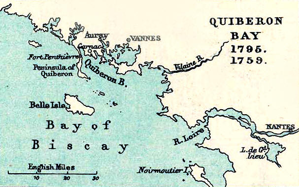
Map Description Historical Map of Quiberon Bay 1759 and 1795
Illustrating
- Bay of Biscay - Belle Isle (Belle Île), Peninsula of Quiberon, Noirmoutier Island (Noirmoutier-en-l'Île) - Fort Penthievre (Penthièvre) - Carnac (Karnag), Auray, Vannes, Nantes - Vilaine River (Gwilen), River Loire - Lac de Grand-Lieu
- Bay of Biscay
- Belle Isle (Belle Île), Peninsula of Quiberon, Noirmoutier Island (Noirmoutier-en-l'Île)
- Fort Penthievre (Penthièvre)
- Carnac (Karnag), Auray, Vannes, Nantes
- Vilaine River (Gwilen), River Loire
- Lac de Grand-Lieu
Credits University of Texas at Austin. From The Public Schools Historical Atlas edited by C. Colbeck, 1905.
Related Links About Quiberon About the Battle of Quiberon Bay in 1759 About the Battle of Quiberon Bay in 1795
About the Seven Years' War About the French Revolution About the French Revolutionary Wars
Related Maps Map of France before 1789 Map of France in 1791
More History
People in History Historic People - Main People in History A - C People in History D - F People in History G - I People in History J - M People in History N - Q People in History R - Z Royal Families Tribes & Peoples Explorers, Scientists & Inventors Musicians, Painters & Artists Poets, Writers & Philosophers First Ladies Native Americans & The Wild West Troublemakers Historians Archaeologists
Wars, Battles & Revolutions Wars & Revolutions A Wars & Revolutions B - E Wars & Revolutions F - G Wars & Revolutions H - J Wars & Revolutions K - O Wars & Revolutions P - R Wars & Revolutions S - Z Wars & Revolutions Chronological Battles A - C Battles D - L Battles M - P Battles Q - Z Battles Ancient Times - 1499 Battles 1500 - 1799 Battles 1800 - Today
Miscellaneous History Dictionary A - F History Dictionary G - Z Source Text - By Title Source Text - By Author Historic Documents A - Z Historic Documents Chronological History News Research Downloads Bored?Castles and Palaces Kids & History Browse About Us Write Me
Sitemaps
Sitemap 01 Sitemap 02 Sitemap 03 Sitemap 04 Sitemap 05 Sitemap 06 Sitemap 07 Sitemap 08 Sitemap 09 Sitemap 10 Sitemap 11 Sitemap 12 Sitemap 13 Sitemap 14 Sitemap 15 Sitemap 16 Sitemap 17 Sitemap 18 Sitemap 19 Sitemap 20 Sitemap 21 Sitemap 22 Sitemap 23
Site Search
HISTORY IN A NUTSHELL
© 2016 Emerson Kent