|
Map Description
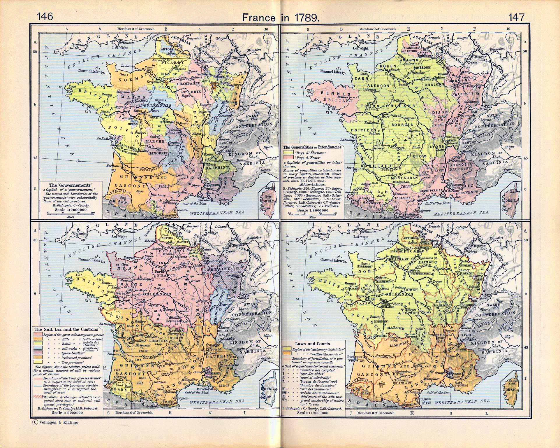
Historical Map of France in
1789.
Illustrating:
Top Left
The gouvernements and their capitals.
Top Right
The generalities
(généralités) or intendancies and their capitals.
- Pays d'Elections (pays d'élections)
- Pays d'Etats (pays d'états)
- Provinces / Districts
Bottom Left
The Salt Tax and the Customs.
- Region of the great salt tax (grande gabelle)
- Region of the Rethel salt tax (gabelle du Rethelois)
- Region of the salt-works tax (gabelle de salines)
- Region of the quart-boullion
- Region of the redeemed provinces
- Region of the free provinces
- The figures show the relative prices paid for a certain amount
of salt in various parts of France.
- Boundary of the cinq grosses germes, i.e. subject to
the tariff of 1664
- Boundary of the provinces réputées étrangères au royaume,
i.e. as regards the tariff of 1664
- Provinces d'étrangèr effectif, i.e. acquired since
1664, or endowed with special privileges
- B. = Bishopric / C. = County / LAB. = Labourd
Bottom Right
Laws and Courts.
- Region of the "customary (feudal) law"
- Region of the "written (Roman) law"
- Boundary of jurisdiction of a parlement or supreme
council
- Seat of a parlement of conseil souverain
- Seat of a chambre des comptes
- Seat of a cour des aides
- Seat of an admiralty
- Seat of a bureau de finance and chambre du domaine
- Seat of a cour des monnaies
- Seat of a prévôts des maréchaux
- Seat of a chief court of the salt tax
- Seat of a grand mastership of waters and forests
- B. = Bishopric / C. = County / LAB. = Labourd
Credits
University of Texas at Austin.
Historical Atlas by William Shepherd (1911).
Related Links
 Parlement (French Revolution
Glossary)
 About the gabelle
 Timeline of the French Revolution
 About the French Revolution
 About the French Revolutionary Wars
 About King Louis XVI
 About Charles Alexandre de Calonne
 Taxation in Pre-Revolutionary France
 List of French comptrollers-general

More History
 |