Map Description

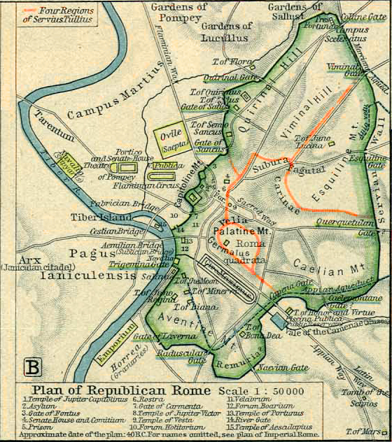
Historical Map of Republican Rome around 40 BC.


This was during the Second Triumvirate period after Caesar's assassination (44 BC), with Rome transitioning from Republic to Empire.

Octavian (later Augustus), Antony, and Lepidus were dividing power.

The Forum Romanum was being transformed from a republican civic center to an imperial showcase, while the city as well was experiencing major building projects, as ambitious politicians used architecture to demonstrate power and win popular support — a practice that would accelerate under Augustus.

The Campus Martius (Field of Mars) was beginning its transformation from training grounds to monumental district with theaters and public buildings.


Illustrating

Four Regions of Servius Tullius

This refers to the first administrative division of the city of Rome, traditionally attributed to Servius Tullius, the sixth king of Rome who ruled in the 6th century BC (according to Roman tradition, approximately 578-535 BC).

According to Roman historical tradition, Servius Tullius divided the city of Rome into four urban administrative regions or districts:

  1. Suburana (or Sucusana) - the eastern district including the Caelian Hill and parts of the Esquiline
  2. Esquilina - covering the Esquiline Hill
  3. Collina - covering the Quirinal and Viminal Hills
  4. Palatina - including the Palatine Hill and Forum area


Servius Tullius' four-region division of Rome was historically significant for establishing one of Rome's earliest urban planning systems, organizing citizens for military service, taxation, and voting, and complementing his Centuriate Assembly (Comitia Centuriata) reform that classified citizens by wealth for political and military purposes.

By the late Republic (around 40 BC), these original four regions were becoming inadequate for the expanded city. Later, Augustus would reorganize Rome into fourteen regions to better administer the much larger imperial capital.

Illustrating further:

  1. Temple of Jupiter Capitolinus

    The most important temple in Rome, dedicated to the Capitoline Triad (Jupiter, Juno, and Minerva). It housed the Sibylline Books and was where consuls made sacrifices upon taking office. This temple symbolized Rome's divine protection and imperial destiny.

  2. Asylum

  3. Gate of Fontus

  4. Senate House (Curia) and Comitium

    This was the political heart of Republican Rome. The Senate met in the Curia to debate policy, while the Comitium was an open-air meeting place where public assemblies were held.

    By 40 BC, Julius Caesar had begun rebuilding the Curia (as the Curia Julia) after it was destroyed by fire.

  5. Prison (Carcer)

    One of the oldest structures in Rome, where enemies of the state were executed. Jugurtha, Vercingetorix, and many of Catiline's conspirators met their end here.

  6. Rostra

    This speakers' platform in the Forum was decorated with the beaks (rostra) of captured enemy ships. In 44 BC, this was where Mark Antony delivered his famous funeral oration for Julius Caesar, which Shakespeare later immortalized with "Friends, Romans, countrymen..."

  7. Gate of Carmenta

  8. Temple of Jupiter Victor

  9. Temple of Vesta

    This round temple housed the sacred eternal flame of Rome, tended by the Vestal Virgins. The flame symbolized the hearth of Rome and its continuation was believed essential to Rome's survival. The adjacent House of the Vestals shows how important these priestesses were in Roman society.

  10. Forum Holitorium (Vegetable Market)

  11. Velarium

  12. Forum Boarium (Cattle Market)

  13. Temple of Portunus

  14. River Gate

  15. Temple of Aesculapius


Credits

University of Texas at Austin. Historical Atlas by William Shepherd (1923-26).


Related Maps

Map of the Vicinity of Rome
Map of Rome AD 350
Map of the Roman Bishoprics 12th Century

Related Links

About the Roman Republic
About the Roman Empire
About Ancient Rome

Click map to see original size.
Map of Republican Rome 40 BC
×
Map of Republican Rome 40 BC


More History