History for the Relaxed Historian
HISTORY FOR THE RELAXED HISTORIAN

PEOPLE IN HISTORY          WARS, BATTLES AND REVOLUTIONS          MAP ARCHIVE          FAMOUS SPEECHES


GOVERNMENTS IN HISTORY          HISTORIC DOCUMENTS          HISTORIC PLACES AND LOCATIONS          ALL-TIME RECORDS IN HISTORY


SOURCE TEXT          SOURCE DOCUMENTS          HISTORY DICTIONARY          TIMELINES          ARCHAEOLOGICAL RECORDS


HOME   -   HISTORY MAPS   -   India 1700-1792


Famous Animals in History


About Mata Hari


The Ancient Greeks in a Nutshell
 

Map Description
Historical Map of India 1700-1792

Illustrating

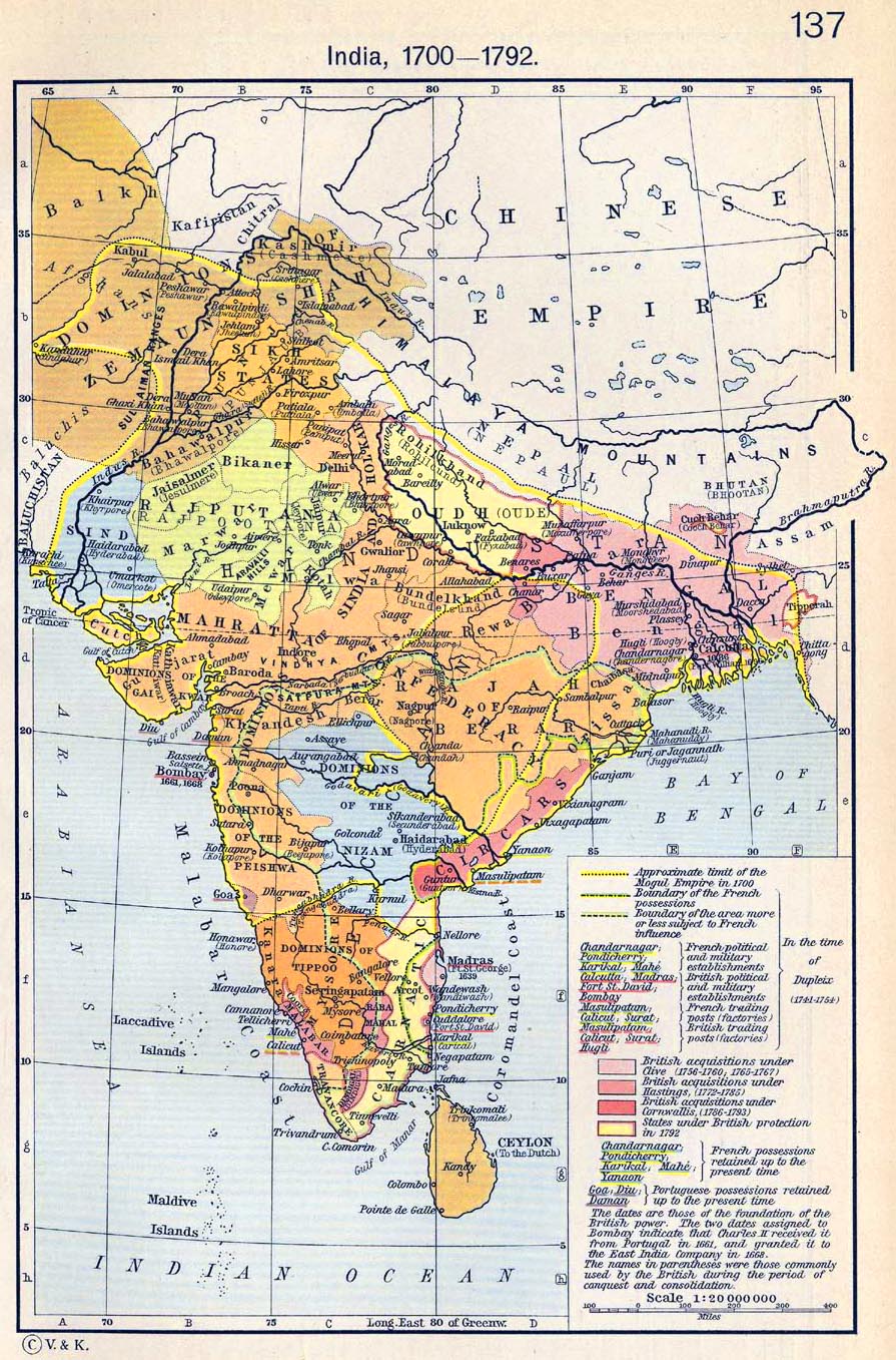
Approximate limit of the Mogul Empire in 1700

In the time of Dupleix (1741-1754):
- Boundary of the French possessions
- Boundary of the area more or less subject to French influence
- French political and military establishments: Chandarnagar, Pondicherry (Pondichéry), Karikal, Mahe
- British political and military establishments: Calcutta, Madras, Fort St. David, Bombay
- French trading posts (factories): Masulipatam, Calicut, Surat
- British trading posts (factories): Masulipatam, Calicut, Surat, Hugli


British acquisitions under Clive (1756-1760, 1765-1767)
British acquisitions under Hastings (1772-1785
British acquisitions under Cornwallis (1786-1793)
States under British protection in 1792


French possessions retained up to the present time (1911):
Chandarnagar, Pondicherry (Pondichéry), Karikal, Mahe, Yanaon

Portuguese possessions retained up to the present time (1911):
Goa, Diu, Daman


The dates are those of the foundation of the British power. The two dates assigned to Bombay
indicate that Charles II received it from Portugal in 1661, and granted it to the East India
Company in 1668.

The names in parentheses were those commonly used by the British during the period of conquest
and consolidation.


Credits
University of Texas at Austin. Historical Atlas by William Shepherd (1911).


Related Maps
Map of India and the Malay Archipelago, 1498-1580     Map of India: The Beginnings of the British Dominion    

Map of India in 1804: The Mysore & Maratha Wars 1792-1804     Map of the Eastern Frontier of India: French and English Expansion 1805-1907

Map of Northern India: The Mutiny 1857-1859     Map of India: British Expansion 1805-1910     Map of the Western Frontier of India


Map of India 1700-1792


More History


People in History

Historic People - Main

People in History A - C

People in History D - F

People in History G - I

People in History J - M

People in History N - Q

People in History R - Z

Royal Families

Tribes & Peoples

Explorers, Scientists & Inventors

Musicians, Painters & Artists

Poets, Writers & Philosophers

First Ladies

Native Americans & The Wild West

Troublemakers

Historians

Archaeologists


Wars, Battles & Revolutions

Wars & Revolutions A

Wars & Revolutions B - E

Wars & Revolutions F - G

Wars & Revolutions H - J

Wars & Revolutions K - O

Wars & Revolutions P - R

Wars & Revolutions S - Z

Wars & Revolutions Chronological

Battles A - C

Battles D - L

Battles M - P

Battles Q - Z

Battles Ancient Times - 1499

Battles 1500 - 1799

Battles 1800 - Today


Miscellaneous


History Dictionary A - F

History Dictionary G - Z

Source Text - By Title

Source Text - By Author

Historic Documents A - Z

Historic Documents Chronological

History News

Research

Downloads


Bored?

Castles and Palaces


Kids & History

Browse

About Us

Write Me


Sitemaps

Sitemap 01   Sitemap 02   Sitemap 03    Sitemap 04   Sitemap 05   Sitemap 06  
Sitemap 07   Sitemap 08   Sitemap 09    Sitemap 10   Sitemap 11   Sitemap 12
Sitemap 13   Sitemap 14   Sitemap 15    Sitemap 16   Sitemap 17   Sitemap 18
Sitemap 19   Sitemap 20   Sitemap 21    Sitemap 22   Sitemap 23


Site Search


HISTORY IN A NUTSHELL


© 2016 Emerson Kent