History for the Relaxed Historian
HISTORY FOR THE RELAXED HISTORIAN

PEOPLE IN HISTORY          WARS, BATTLES AND REVOLUTIONS          MAP ARCHIVE          FAMOUS SPEECHES


GOVERNMENTS IN HISTORY          HISTORIC DOCUMENTS          HISTORIC PLACES AND LOCATIONS          ALL-TIME RECORDS IN HISTORY


SOURCE TEXT          SOURCE DOCUMENTS          HISTORY DICTIONARY          TIMELINES          ARCHAEOLOGICAL RECORDS


HOME   -   HISTORY MAPS   -   CANADA AND NEWFOUNDLAND 1623-1905


Map Description
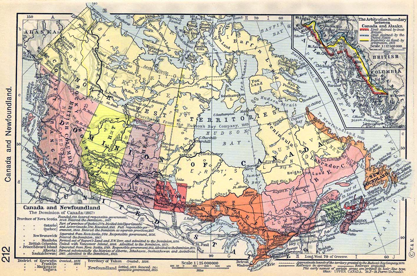
Historical Map of Canada and Newfoundland 1623-1905.

Illustrating

The Dominion of Canada (1867)

- Province of Nova Scotia - Founded 1713. Secured responsible government 1848. Entered
  the Dominion 1867

- Province of Ontario and Province of Quebec - Part of province of Quebec 1774. Divided
  into Upper Canada and Lower Canada 1791. Reunited 1841. Full responsible government
  1849. Entered the Dominion as separate provinces 1867.

- Province of New Brunswick - Separated from Nova Scotia 1784. Responsible government
  1836. Entered the Dominion 1867.

- Province of Manitoba - Formed out of Rupert's Land and N.W. Terr. and admitted to the
  Dominion 1870.

- Province of British Columbia - United with Vancouver Island 1866. Admitted to the Dominion
  1871.

- Province of Prince Edward Island - Separated from Nova Scotia 1769. Responsible government
  1851. Admitted to the Dominion 1871.

- Province of Alberta and Province of Saskatchewan - Formed substantially the Districts of
  Alberta, Athabasca, Saskatchewan and Assiniboia, 1882. Admitted to the Dominion 1905

- District of Keewatin - Created 1876

- District of Franklin - Created 1895

- District of Mackenzie - Created 1895

- District of Ugava - Created 1895

- Territory of Yukon - Created 1898

- Newfoundland - Settled 1623, Secured responsible government 1855

- Approximate bounds of the territory granted to the
Hudson's Bay Company 1670

- Railways in operation

- Railways projected

The early names of certain areas are printed in hair-line type.


Inset: The Arbitration Boundary between Canada and Alaska

Illustrating

- Limit claimed by Great Britain
- Limit claimed by the United States
- Boundary as fixed by arbitration 1903


Credits
University of Texas at Austin. Historical Atlas by William Shepherd (1911).


Related Maps
Map of the Dominion of Canada and Newfoundland


Map of Canada and Newfoundland 1623-1905


More History


People in History

Historic People - Main

People in History A - C

People in History D - F

People in History G - I

People in History J - M

People in History N - Q

People in History R - Z

Royal Families

Tribes & Peoples

Explorers, Scientists & Inventors

Musicians, Painters & Artists

Poets, Writers & Philosophers

First Ladies

Native Americans & The Wild West

Troublemakers

Historians

Archaeologists


Wars, Battles & Revolutions

Wars & Revolutions A

Wars & Revolutions B - E

Wars & Revolutions F - G

Wars & Revolutions H - J

Wars & Revolutions K - O

Wars & Revolutions P - R

Wars & Revolutions S - Z

Wars & Revolutions Chronological

Battles A - C

Battles D - L

Battles M - P

Battles Q - Z

Battles Ancient Times - 1499

Battles 1500 - 1799

Battles 1800 - Today


Miscellaneous


History Dictionary A - F

History Dictionary G - Z

Source Text - By Title

Source Text - By Author

Historic Documents A - Z

Historic Documents Chronological

History News

Research

Downloads


Bored?

Castles and Palaces


Kids & History

Browse

About Us

Write Me


Sitemaps

Sitemap 01   Sitemap 02   Sitemap 03    Sitemap 04   Sitemap 05   Sitemap 06  
Sitemap 07   Sitemap 08   Sitemap 09    Sitemap 10   Sitemap 11   Sitemap 12
Sitemap 13   Sitemap 14   Sitemap 15    Sitemap 16   Sitemap 17   Sitemap 18
Sitemap 19   Sitemap 20   Sitemap 21    Sitemap 22   Sitemap 23


Site Search


HISTORY IN A NUTSHELL


© 2016 Emerson Kent