PEOPLE IN HISTORY WARS, BATTLES AND REVOLUTIONS MAP ARCHIVE FAMOUS SPEECHES
GOVERNMENTS IN HISTORY HISTORIC DOCUMENTS HISTORIC PLACES AND LOCATIONS ALL-TIME RECORDS IN HISTORY
SOURCE TEXT SOURCE DOCUMENTS HISTORY DICTIONARY TIMELINES ARCHAEOLOGICAL RECORDS
HOME - HISTORY MAPS - South America 1910
History Map Archive Search chronologically or by continent.
WORLD MAPS AFRICA MAPS AMERICA MAPS: A - D AMERICA MAPS: E - N AMERICA MAPS: O - S AMERICA MAPS: T - Z ASIA MAPS: A - C ASIA MAPS: D - I ASIA MAPS: J - O ASIA MAPS: P - Z AUSTRALIA AND PACIFIC EUROPE MAPS: A - B EUROPE MAPS: C - D EUROPE MAPS: Ea-Et EUROPE MAPS: Eu-Ez EUROPE MAPS: F EUROPE MAPS: G EUROPE MAPS: H - I EUROPE MAPS: J - N EUROPE MAPS: O - Q EUROPE MAPS: R EUROPE MAPS: S EUROPE MAPS: T - Z
Ancient Times - 401 BC
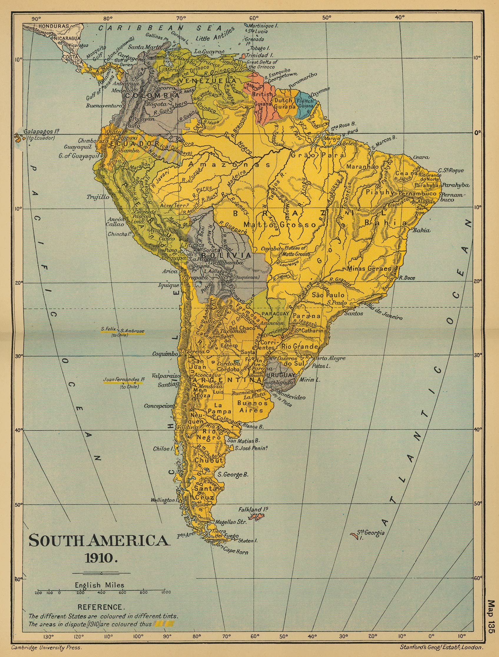
Map Description History Map of South America 1910
Illustrating
The different States are colored in different tints. The areas in dispute (1910) Panama, Colombia, Venezuela British Guiana, Dutch Guiana, French Guiana, Ecuador, Brazil, Peru, Bolivia, Chile, Paraguay, Argentina, Uruguay
The different States are colored in different tints. The areas in dispute (1910)
Panama, Colombia, Venezuela British Guiana, Dutch Guiana, French Guiana, Ecuador, Brazil, Peru, Bolivia, Chile, Paraguay, Argentina, Uruguay
Credits The University of Texas at Austin. From the Cambridge Modern History Atlas, 1912.
Related Maps Map of South America 1790-1911 Map of Chile 1974
More History
People in History Historic People - Main People in History A - C People in History D - F People in History G - I People in History J - M People in History N - Q People in History R - Z Royal Families Tribes & Peoples Explorers, Scientists & Inventors Musicians, Painters & Artists Poets, Writers & Philosophers First Ladies Native Americans & The Wild West Troublemakers Historians Archaeologists
Wars, Battles & Revolutions Wars & Revolutions A Wars & Revolutions B - E Wars & Revolutions F - G Wars & Revolutions H - J Wars & Revolutions K - O Wars & Revolutions P - R Wars & Revolutions S - Z Wars & Revolutions Chronological Battles A - C Battles D - L Battles M - P Battles Q - Z Battles Ancient Times - 1499 Battles 1500 - 1799 Battles 1800 - Today
Miscellaneous History Dictionary A - F History Dictionary G - Z Source Text - By Title Source Text - By Author Historic Documents A - Z Historic Documents Chronological History News Research Downloads Bored?Castles and Palaces Kids & History Browse About Us Write Me
Sitemaps
Sitemap 01 Sitemap 02 Sitemap 03 Sitemap 04 Sitemap 05 Sitemap 06 Sitemap 07 Sitemap 08 Sitemap 09 Sitemap 10 Sitemap 11 Sitemap 12 Sitemap 13 Sitemap 14 Sitemap 15 Sitemap 16 Sitemap 17 Sitemap 18 Sitemap 19 Sitemap 20 Sitemap 21 Sitemap 22 Sitemap 23
Site Search
HISTORY IN A NUTSHELL
© 2016 Emerson Kent