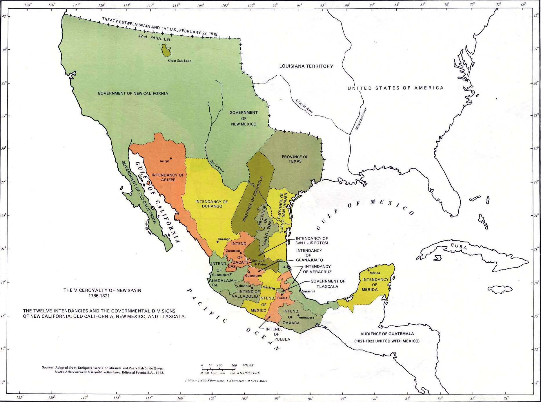
Historical Map of Mexico — The Viceroyalty of New Spain, 1786-1821.
Illustrating
The Twelve Intendancies and the Governmental Divisions of New California, Old California,
New Mexico, and Tlaxcala.
42nd parallel:
Treaty between Spain and the U.S. February 22, 1819
(Adams-Onis Treaty)
Great Salt Lake
Government of New California
Government of New Mexico
Government of Old California
Gulf of California
Intendancy of Arizpe
Intendancy of Durango
Rio Grande
Arkansas River
Louisiana Territory
Mississippi River
United States of America
Province of Texas
province of Coahuila
Province of Nuevo Santander
Province of Nuevo Leon
Intendancy of Zacatecas
Intendancy of San Luis Potosi
Intendancy of Guanajuato
Intendancy of Veracruz
Government of Tlaxcala
Intendancy of Guadalajara
Intendancy of Valladolid
Intendancy of Mexico
Intendancy of Puebla
Intendancy of Oaxaca
Antequera
Intendancy of Merida
Gulf of Mexico
Audience of Guatemala (1821-1823 united with Mexico)
Cuba
Pacific Ocean
Source:
Adapted from Enriqueta Garcia de Miranda and Zaida Falcon de
Gyves, Nuevo Atlas Porrua de la Republica Mexicana, Editorial
Porrua, S.A. 1972
Creation of Intendancies
In 1786, King Charles III divided New Spain into twelve intendancies,
each governed by an intendant who reported directly to the crown. This structure aimed to improve
tax collection and local governance.
Independence Movements
The early 19th century was marked by increasing unrest fueled by Enlightenment ideas and dissatisfaction
with colonial rule. The independence movement gained momentum with figures like Miguel Hidalgo
and José María Morelos,
who called for social reforms and national sovereignty starting in 1810. Although these efforts initially faced setbacks,
they laid the groundwork for a broader revolution.
The culmination of these revolutionary activities occurred in 1821 when a coalition led
by Agustín de Iturbide successfully
declared independence from Spain. This marked the end of the Viceroyalty of New Spain, transitioning into a new political
entity — the Mexican Empire.
Credits
Used by permission of the University of Texas Libraries, The University of Texas at Austin.