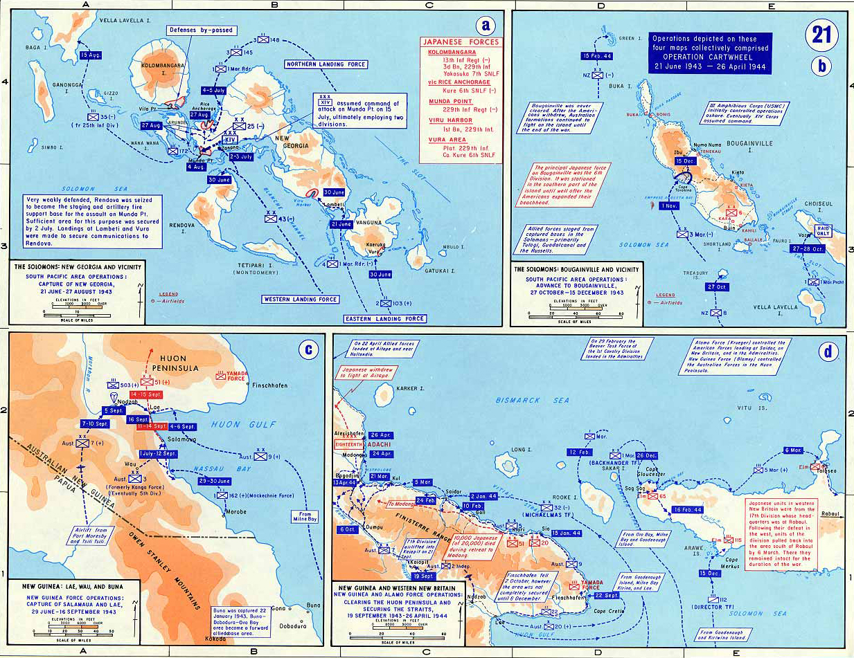
Map Description
History Map of WWII: The Solomons and New Guinea June 1943 - April 1944
Illustrating:
OPERATION CARTWHEEL
21 June 1943 - 26 April 1944
Operation Cartwheel was a major Allied campaign in the Southwest Pacific during World War II,
designed to neutralize the heavily fortified Japanese base at Rabaul on New Britain by isolating it rather than capturing it directly.
The operation involved a series of coordinated land, sea, and air offensives across the Solomon Islands and New Guinea.
It was jointly directed by General Douglas MacArthur, Supreme Commander of Allied Forces in the
Southwest Pacific Area, and
Admiral William F. Halsey, commander of the South Pacific Area.
The campaign employed a strategy of bypassing major enemy strongholds,
seizing key islands and constructing airfields to establish a network of forward bases. This incremental advance allowed the Allies to
apply continuous pressure on Japanese defenses, setting the stage for the liberation of the Philippines and the eventual push toward Japan.
While the “island hopping” concept is more commonly associated with Central Pacific operations, the strategic principles were similarly
employed in Operation Cartwheel to great effect.
Map ⓐ
The Solomons: New Georgia and Vicinity
South Pacific Area Operations: Capture of New Georgia, 21 June - 27 August, 1943
The New Georgia campaign (21 June – 27 August 1943) aimed to secure the central Solomon Islands as a staging ground for
operations against Rabaul. Allied forces, primarily American, conducted a series of amphibious landings and engaged in
intense jungle warfare to capture Munda Point, where the Japanese had constructed a strategically important airfield.
Resistance was fierce, and progress was hampered by difficult terrain and determined Japanese counterattacks. However,
the Allies employed a strategy of encirclement, supported by naval gunfire and airpower, to isolate and weaken enemy positions.
After more than two months of combat, the Japanese were forced to withdraw, and the airfield at Munda was secured, providing
a vital base for further advances up the Solomon chain.
Map ⓑ
The Solomons: Bougainville and Vicinity
South Pacific Area Operations: Advance to Bougainville, 27 October - 15 December, 1943
The Bougainville campaign began with amphibious landings at Cape Torokina on 1 November 1943, as part of a broader effort to
neutralize Rabaul by cutting it off from supply and reinforcement. Rather than attempting to seize the entire island, which
was held by a large Japanese garrison, Allied forces focused on establishing a secure perimeter on the island’s western coast.
Within this zone, they rapidly constructed airfields to support sustained aerial bombardment of Rabaul and other Japanese bases.
The strategy of holding a limited area allowed the Allies to avoid costly frontal assaults while tying down tens of thousands
of Japanese troops in static defensive positions. Although Japanese forces launched several counterattacks into early 1944, the
Allied foothold held firm, fulfilling its strategic purpose.
Map ⓒ
New Guinea: Lae, Wau, and Salamaua:
New Guinea Force Operations: Capture of Salanaua and Lae, 29 June - 16 September, 1943
The Lae–Salamaua campaign (29 June – 16 September 1943) in eastern New Guinea demonstrated the Allies’ growing proficiency in
combined arms and maneuver warfare. The operation involved Australian and American forces advancing from multiple directions:
one element moved overland from Wau, while another conducted an amphibious landing east of Lae. In a dramatic airborne operation,
U.S. paratroopers landed at Nadzab, disrupting Japanese supply lines and facilitating a rapid thrust toward Lae. After intense
fighting, Lae fell on 16 September, followed by the withdrawal of Japanese forces from Salamaua. The campaign deprived the
Japanese of vital logistical bases on the Huon Gulf and marked a significant shift in the balance of power in New Guinea.
Please note: The earlier Buna campaign took place from November 1942 to January 1943 and served as a precursor to these
operations, but it was not part of Operation Cartwheel.
Map ⓓ
New Guinea and Western New Britain
New Guinea and Alamo Force Operations: Clearing the Huon Peninsula and Securing the Straits, 19 September, 1943 - 26 April, 1944
From 19 September 1943 to 26 April 1944, Allied forces focused on securing the Huon Peninsula and adjacent areas of western
New Britain. Key objectives included the towns of Finschhafen, Saidor, and Cape Gloucester, and control of the Vitiaz and Dampier
Straits, vital sea lanes between New Guinea and New Britain. The campaign featured coordinated amphibious landings, jungle advances,
and the rapid construction of forward airfields. Rather than directly engaging all Japanese positions, the Allies adopted a policy of
isolation and bypass, leaving enemy garrisons stranded and unable to influence future operations. This approach minimized casualties
and preserved momentum.
By the conclusion of these operations, Allied forces had effectively encircled Rabaul, neutralizing its
strategic value without the need for direct assault.
Credits
Courtesy of the United States Military Academy Department of History.
Related Links
About World War IIWWII Timelines
Click map to enlarge.
More History
