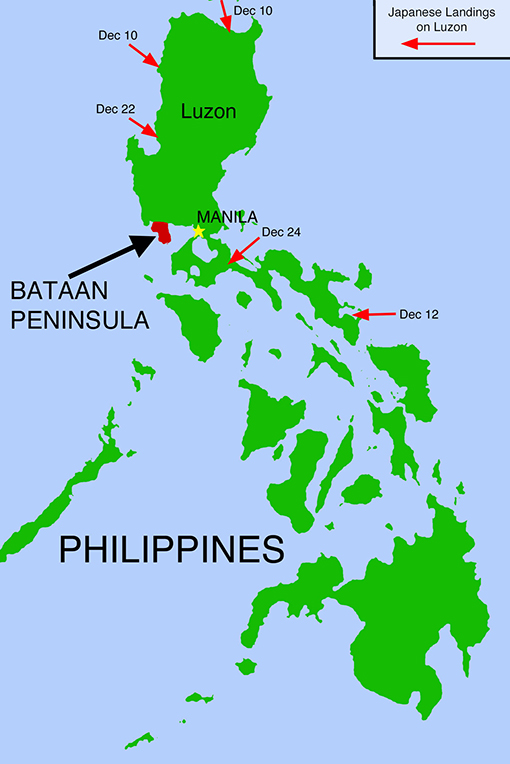
Map Description
History Map of WWII: Philippines, Luzon, and Bataan Peninsula
Illustrating:
Sites and dates of Japanese Landings on Luzon in December 1941
:: Japan's Strategy in a Nutshell ::
The Japanese employed a multi-pronged invasion strategy to encircle and isolate Manila by landing forces on all sides of Luzon. Their objectives were to seize key airfields, disrupt defensive coordination, and rapidly overwhelm Philippine and U.S. forces before they could regroup.
| Date | Direction / Site | Japanese Forces & Materiel | Objective / Notes |
|---|---|---|---|
| Dec 8 | North (Batan Island) | ~490 naval infantry | Secure staging airfield |
| Dec 10 | North (Aparri, Gonzaga) | ~2,000 (48th Div. detachment), naval support, light tanks, artillery | Secure airfields, threaten from north |
| Dec 10 | Northwest (Vigan) | ~2,000 (48th Div. detachment), naval support, light tanks, artillery | Secure airfield, threaten from NW |
| Dec 12 | Southeast (Legazpi) | ~2,500 (16th Div. detachment), naval support, light tanks, artillery | Secure airfield, cut southern retreat |
| Dec 22 | West (Lingayen Gulf: Agoo, Caba, Bauang) | ~43,000 (48th Div., 16th Reg.), ~90 tanks, 60+ ships, artillery | Main invasion, advance to Manila |
| Dec 24 | East (Lamon Bay: Mauban, Atimonan, Siain) | ~7,000 (16th Div.), naval support, light tanks, artillery | Outflank Manila from south/east |
In more detail:
Timeline of Japanese Landings on Luzon, December 1941
Dec 8: Batan Island (120 miles north of Luzon)
- Purpose: Establish a forward air base for fighter support from Formosa.
- Forces: ~490 men (24th Airfield Battalion and naval personnel).
- Opposition: None; airfield construction began immediately.
Dec 10: Northern Luzon — Aparri and Gonzaga (Cagayan Province)
- Forces: ~2,000 troops (Tanaka Detachment, 48th Division), cruiser Natori, destroyers.
- Equipment: Light tanks, limited artillery, air support from Formosa.
- Objective: Secure airfields and facilitate pincer movement toward central Luzon.
- Opposition: Elements of the Philippine 11th Division, lightly equipped.
Dec 10: Northwest Luzon — Vigan (Ilocos Sur Province)
- Forces: ~2,000 troops (Kanno Detachment, 48th Division), naval support.
- Equipment: Light tanks, artillery, air support.
- Objective: Secure Vigan airfield, pressure northern Luzon defenses.
- Opposition: Minimal ground resistance; U.S. air attacks inflicted some losses.
Dec 12: Southeast Luzon — Legazpi (Albay Province)
- Forces: ~2,500 troops (Sato Detachment, 16th Division), naval escort.
- Equipment: Light tanks, artillery.
- Objective: Capture airfield; cut off southern routes of retreat and reinforcement.
- Opposition: Virtually none; defenders withdrew in good order.
Dec 22: Western Luzon — Lingayen Gulf (Pangasinan and La Union)
- Sites: Agoo, Caba, Bauang.
- Forces: ~43,000 troops (mainly 48th Division, elements of 16th Division), ~90 tanks, 60+ naval vessels.
- Objective: Major landing to drive south toward Manila.
- Opposition: Philippine 11th and 71st Divisions, U.S. artillery and limited armor support.
Dec 24: Eastern Luzon — Lamon Bay (Quezon Province)
- Sites: Mauban, Atimonan, Siain.
- Forces: ~7,000 troops (20th Infantry Regiment, 16th Division), naval escort.
- Equipment: Light tanks, artillery.
- Objective: Outflank Manila from the south and east to complete encirclement.
- Opposition: Light resistance from the Philippine 1st Regular Division.
:: Notes ::
- Japanese forces also landed on Mindanao (Dec 19, Davao), Jolo, and Palawan — outside the Luzon theater.
- Extensive bombing and fighter cover provided from Formosa and newly captured Luzon airfields.
Credits
Courtesy of the National Museum of the USAF.
Related Links
About the Bataan Death MarchTimeline of the Pearl Harbor Attack 1941
About the Second World War
WWII Timelines
Click map to enlarge.
More History
