Map Description
History Map of WWII: The Far East and the Pacific 1942
Illustrating:
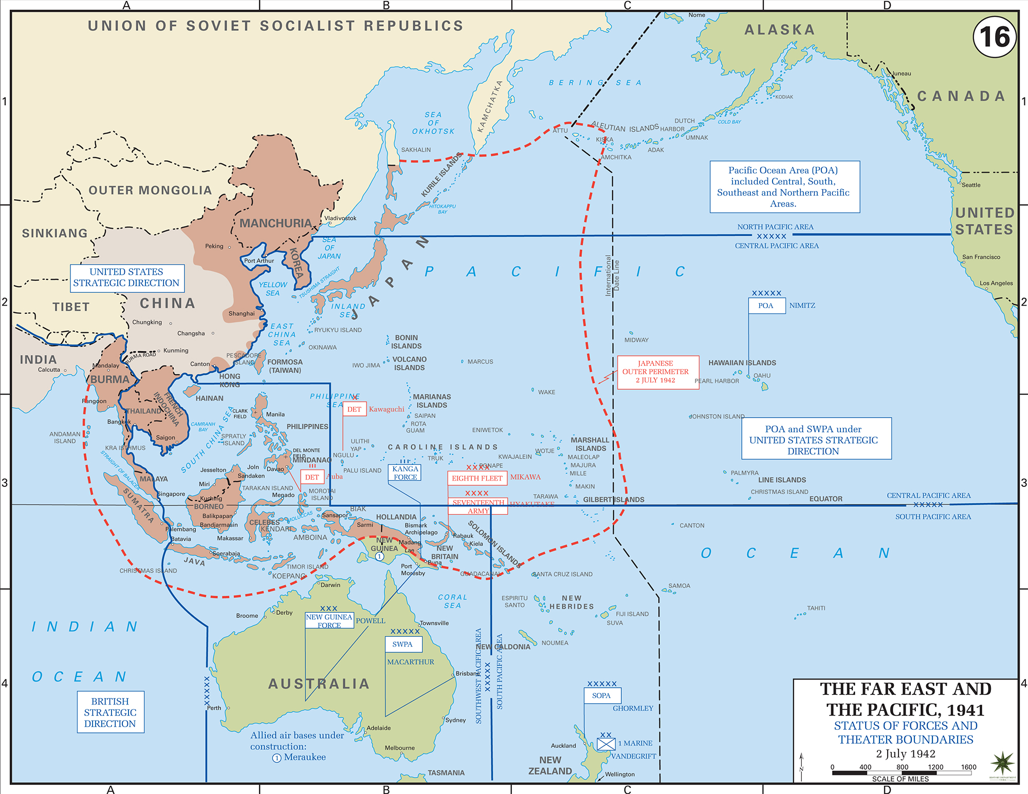
Status of Forces and Theater Boundaries — July 2, 1942
Status of Allied and Japanese Forces
By July 2, 1942, the Japanese Empire had reached its greatest territorial extent in the Pacific, holding most of Southeast Asia,
the Philippines, the Dutch East Indies, and large parts of New Guinea and the Solomon Islands.
The Japanese military presence was organized under two main commands: the Imperial Japanese Navy’s Combined Fleet
(under Admiral Isoroku Yamamoto) and the Imperial Japanese Army’s General Staff. These commands often overlapped geographically
and did not operate under a unified joint command structure.
The Allies, meanwhile, were regrouping after early setbacks. In the Pacific, two major Allied commands were established:
- Pacific Ocean Areas, under Admiral Chester Nimitz, covering most of the Pacific Ocean and its islands.
- South West Pacific Area, under General Douglas MacArthur, including Australia, New Guinea, the Philippines, and parts of the Dutch East Indies.
Allied forces in the region included U.S. Navy, Army, and Marine Corps units, along with forces from Australia, New Zealand,
the United Kingdom, and other nations.
Theater Boundaries and Strategic Situation
On July 2, 1942, the U.S. Joint Chiefs of Staff ordered limited offensives in three stages, aiming to recapture key locations such
as New Britain, New Ireland, the Solomons, and eastern New Guinea.
The boundaries between the Pacific Ocean Areas and the South West Pacific Area were clearly delineated, with each commander responsible
for operations within their respective theaters.
The Japanese were constructing an airfield on Guadalcanal, threatening Allied supply lines to Australia. This prompted the Allies to
plan their first major offensive in the Solomons, which would begin with the Guadalcanal campaign in August 1942.
Credits
Courtesy of the United States Military Academy Department of History.
Related Links
About the Second World WarWWII Timelines
Click map to enlarge.
More History
