|
Roman Britain
English Heritage Foundation
Roman Invasion and
Occupation of
Ancient Britain —
AD 43-410
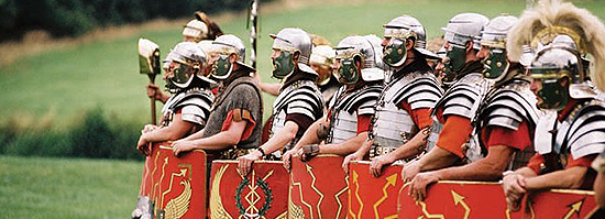
This is Roman Britain and Roman
civilization in Britain in a nutshell.
|
|
Let's kick off with a quote from a pro:
In the Western world,
we often see ourselves as inheritors of Roman values and Roman
culture.
But [...] the Romans
were invaders, colonizers.
Their strategies
encompassed everything up to, and including, genocide.
Dr Fraser Hunter
Curator Archaeology, Roman History
National Museums of Scotland
When Did the Romans
Arrive in Ancient Britain? When Did They Leave?
The Romans invaded Britain in AD 43 under
 Emperor Claudius. Emperor Claudius.
In 410,
Emperor Honorius encouraged
British towns to grow a pair because Rome would discontinue all military support. Henceforth, the people of Britannia
had to fight for themselves.
However, the use of the year 410 as
the exact time of the departure of all Roman forces, the severance
of all British ties to Rome, and the cessation of Roman longing for
control over Britain would be an oversimplification of the actual
events.
|
But thus cautioned, let's say the Roman
invasion and occupation of ancient
Britain stretched from
43-410.
This time period can be divided into
three chapters — conquest, occupation, and settlement.
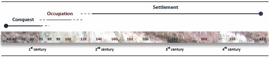
Timeline of Roman Britain
CADW
What About Julius
Caesar's Visit to Ancient Britain?
It's true,
Julius Caesar invaded
Britain twice, in 55 BC and again in 54 BC. But he also left again
each time soon after.
Britain did not become part of the
Roman Empire as a result of Julius Caesar's invasions. Nor did the
Romans follow up on his short-lived conquests. At least not for
another century.
Did the Romans Ever
Conquer Britain Completely?
They did not, as any Scot today will be
delighted to point out.
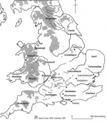
Here is the map of the Roman advance
in Britain:
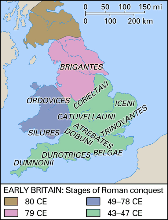
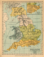
Map of Early Britain: Stages of Roman Conquest
Illustrating Roman conquest from AD 43-47, from
49-78, until 79, and until 80
(See more under
Timeline of Roman Britain)
Early British tribes: Brigantes, Ordovices,
Silures, Corieltavi, Iceni, Catuvellauni,
Trinovantes, Atrebates, Dobunni, Belgae,
Durotriges, Dumnonii
Encyclopaedia Britannica Map
By the way,
should it be CE or AD?
Why Did The Romans Withdraw?
Some say that the natives were too tough
to beat.
Others say, the Romans could have conquered and held all of Britain
but they didn't tag it as a priority. They had other fish to fry on
more important frontiers of their large empire.
The truth
is probably a mixture of both.
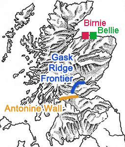
What Was the
Northernmost Point the Romans Reached?
As far as frontier lines are concerned, the
Gask Ridge frontier of
AD 83 was probably the northernmost frontier. Much better fortified was
of course the Antonine Wall of 142.
However, the Romans trekked all the way up to the Moray Firth. There
are remains of a Roman
marching camp at Bellie, and a large coin hoard was
found at Birnie.
|
 |
 |
|
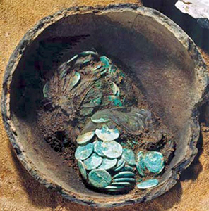
Map Location of Birnie and Bellie |
Coin Hoard at Birnie: 627 Coins |
|
Birnie is located 10 miles west of Bellie,
Moray, Scotland, UK |
Two pots of coins, the latest dated
to AD 193, the reign of Septimius
Severus |
|
National Museums Scotland |
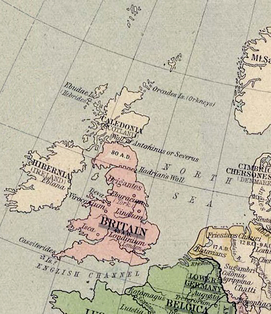
The Orkney Islands (the Orcades) were mentioned, but never
occupied.
All in all, the Romans launched 3 major campaigns into modern day
Scotland:
1st Campaign led by Roman's Governor of
Britain
Agricola
(77-84)
2nd Campaign under Emperor
Antoninus Pius
(138-161)
3rd Campaign under
Septimius Severus (193-211)
What's the
Limes?
The plural is limites.
Originally, a limes was a path, passage, road, way, or track. Later it stood for
boundary, border, or frontier.
The best documented limites in Great Britain are
Hadrian's Wall
and the
Antonine Wall.
Another important limes ran across the European mainland, see here:
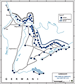
2nd Century AD Limes
in Germany
Britain Before
Claudius' Invasion in AD 43
100 BC
The
Belgae
begin to migrate from Northern France and settle in Britain, pushing
the native tribes further inland.
58 BC
The
Gallic Wars
begin. Rome vs. the tribes of Gaul.
55 BC
In August of 55
BC, Julius Caesar launches his first British invasion. He has 100
warships and 2 legions, or 10,000 troops, at his disposal.
54 BC
Julius Caesar's second and last
invasion of Britain. This time he brings with him 800 warships, 5
legions, and 2,000 cavalry.
The
Trinovantes become a Roman ally, and together they defeat
Cassivellaunus, the king of the
Catuvellauni tribe.
Here is an excerpt from Julius Caesar's notes:
. . . greater forces of the Britons had already assembled at that place,
the chief command and management of the war having been intrusted to
Cassivellaunus, whose territories a river, which is called the
Thames, separates, from the maritime states at about eighty miles
from the sea. At an earlier period perpetual wars had taken place
between him and the other states; but, greatly alarmed by our
arrival, the Britons had placed him over the whole war and the
conduct of it.
The interior portion of Britain is
inhabited by those of whom they say that it is handed down by
tradition that they were born in the island itself: the maritime
portion by those who had passed over from the country of the Belgae
for the purpose of plunder and making war; almost all of whom are
called by the names of those states from which being sprung they
went thither, and having waged war, continued there and began to
cultivate the lands.
The number of the people is countless, and
their buildings exceedingly numerous, for the most part very like
those of the Gauls: the number of cattle is great.
They use either
brass or iron rings, determined at a certain weight, as their money.
Tin is produced in the midland regions; in the maritime, iron; but
the quantity of it is small: they employ brass, which is imported.
There, as in Gaul, is timber of every description, except beech and
fir. They do not regard it lawful to eat the hare, and the cock, and
the goose; they, however, breed them for amusement and pleasure. The
climate is more temperate than in Gaul, the colds being less severe.
The island is triangular in its form,
and one of its sides is opposite to Gaul. One angle of this side,
which is in Kent, whither almost all ships from Gaul are directed,
looks to the east; the lower looks to the south. This side extends
about 500 miles. Another side lies toward Spain and the west, on
which part is Ireland, less, as is reckoned, than Britain, by one
half: but the passage from it into Britain is of equal distance
with that from Gaul.
In the middle of this voyage, is an island,
which is called Mona: many smaller islands besides are supposed to
lie there, of which islands some have written that at the time of
the winter solstice it is night there for thirty consecutive days.
We, in our inquiries about that matter, ascertained nothing, except
that, by accurate measurements with water, we perceived the nights
to be shorter there than on the continent.
The length of this side,
as their account states, is 700 miles. The third side is toward the
north, to which portion of the island no land is opposite; but an
angle of that side looks principally toward Germany. This side is
considered to be 800 miles in length. Thus the whole island is
about 2,000 miles in circumference.
The most civilized of all these
nations are they who inhabit Kent, which is entirely a maritime
district, nor do they differ much from the Gallic customs. Most of
the inland inhabitants do not sow corn, but live on milk and flesh,
and are clad with skins.
All the Britains, indeed, dye themselves
with woad*, which occasions a bluish color, and thereby have a more
terrible appearance in fight. They wear their hair long, and have
every part of their body shaved except their head and upper lip. Ten
and even twelve have wives common to them, and particularly brothers
among brothers, and parents among their children; but if there be
any issue by these wives, they are reputed to be the children of
those by whom respectively each was first espoused when a virgin.
*
Woad, also called
dyerswoad:
(Isatis
tinctoria), biennial or perennial herb,
in a genus of about 80 species in the
mustard family (Brassicaceae), formerly
grown as a source of the blue dye
indigo.
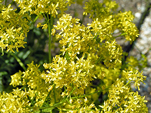
Woad (Isatis tinctoria)
National Education Network
The horse and charioteers of the enemy
contended vigorously in a skirmish with our cavalry on the march;
yet so that our men were conquerors in all parts, and drove them to
their woods and hills; but, having slain a great many, they pursued
too eagerly, and lost some of their men.
But the enemy, after some
time had elapsed, when our men were off their guard, and occupied in
the fortification of the camp, rushed out of the woods, and making
an attack upon those who were placed on duty before the camp, fought
in a determined manner; and two cohorts being sent by Caesar to
their relief, and these severally the first of two legions, when
these had taken up their position at a very small distance from each
other, as our men were disconcerted by the unusual mode of battle,
the enemy broke through the middle of them most courageously, and
retreated thence in safety.
That day, Q. Laberius Durus, a tribune
of the soldiers, was slain. The enemy, since more cohorts were sent
against them, were repulsed.
Julius Caesar
On the Gallic War (De Bello Gallico)
Book V, Chapter 11-15
53 BC
For Britain, a stretch of nearly a
hundred peaceful years begin.
50 BC
Julius Caesar has conquered Gaul.
The
Gallic Wars
end.
49-45 BC
Roman Civil War
AD 10
Tasciovanus, the king of the
Catuvellauni tribe, establishes Verulamium, today's St.
Albans. Death of Tasciovanus. He is succeeded by his son,
Cunobelinus.
The Trinovantes, Julius Caesar's
former allies, are conquered by the Catuvellauni.
AD 42
Cunobelinus, the king of the
Catuvellauni tribe, dies.
Timeline of Roman
Britain AD 43-410
|
Roman Emperor
Claudius (41-54) |
43
Under Claudius, the Romans invade southern England. Claudius himself
takes part in the final maneuvers of his first campaign. The
conquering invasion force consists of approx. 50,000 Roman soldiers.
Britannia becomes a Roman
province.
Some of the native tribes strike a
deal with Rome, like the
Dobunni of Gloucestershire, for
example. Other tribes do not, and are consequently
overrun by the Romans, like the Deceangli
of northern Wales.
And then there are old friends, like
the Trinovantes who had combined
forces with Julius Caesar back in the days. After Caesar's
departure, they were defeated by the Catuvellauni. Now, Claudius
liberates them.
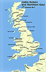
1st Century BC -
Celtic Britain and Northern Gaul - Tribes
Click to enlarge
Ancient Britain -
Tribes
Click to enlarge
|
Roman Governor of Britain
Aulus Plautius (43-46) |
Aulus Plautius is the first Roman
governor of Britain, or legatus Augusti pro
praetore (propraetorian legate [or
deputy] of the emperor).
|
Roman Governor of Britain
Publius Ostorius Scapula (47-52) |
47
The Romans conquer the West Midlands.
And here is a map of Wales from AD 47:
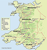
Wales AD 47, Roman Britain
49
The first Roman colony is founded at Camulodunum (today's
Colchester). Here, and in line with Roman emperor
worship, Emperor Claudius orders to build the Temple of Claudius.
50
Publius Ostorius Scapula defeats the Catuvellauni tribe, whose
king, Caratacus, flees to the Brigantes tribe. The queen of the
Brigantes, Cartimandua, hands Caratacus over to the Romans.
|
Roman Governor of Britain
Aulus Didius Gallus (52-57) |
|
Roman Emperor
Nero (54-68) |
|
Roman Governor of Britain
Quintus Veranius (57/58) |
|
Roman Governor of Britain
Gaius Suetonius Paullinus (59-61) |
60
The Iceni tribe, led by their Queen
Boudicca,
and the Trinovantes tribe revolt against Rome. Meanwhile, Governor Suetonius
Paullinus wages his war on druids on the island of Mona (today's Anglesey).
The rebels
take advantage of the Governor's absence and sack Camulodunum (today's
Colchester).
Some residents of Camulodunum
barricade themselves in the city's Temple of Claudius. The rebels besiege the
temple for two days, after which they burn it, its defenders, and the entire town
to the ground.
And here is
Tacitus' account of the
events in 60 and 61:
Now, however, Britain was in
the hands of Suetonius Paulinus, who in
military knowledge and in popular favour,
which allows no one to be without a rival,
vied with Corbulo, and aspired to equal the
glory of the recovery of Armenia by the
subjugation of Rome's enemies. He therefore
prepared to attack the island of Mona which
had a powerful population and was a refuge
for fugitives. He built flat-bottomed
vessels to cope with the shallows, and
uncertain depths of the sea. Thus the
infantry crossed, while the cavalry followed
by fording, or, where the water was deep,
swam by the side of their horses.
On the shore stood the opposing army
with its dense array of armed warriors,
while between the ranks dashed women, in
black attire like the Furies, with hair dishevelled, waving brands. All around, the
Druids, lifting up their hands to heaven,
and pouring forth dreadful imprecations,
scared our soldiers by the unfamiliar sight,
so that, as if their limbs were paralysed,
they stood motionless, and exposed to
wounds. Then urged by their general's
appeals and mutual encouragements not to
quail before a troop of frenzied women, they
bore the standards onwards, smote down all
resistance, and wrapped the foe in the
flames of his own brands. A force was next
set over the conquered, and their groves,
devoted to inhuman superstitions, were
destroyed. They deemed it indeed a duty to
cover their altars with the blood of
captives and to consult their deities
through human entrails.
Suetonius while thus occupied
received tidings of the sudden revolt of the
province. Prasutagus, king of the Iceni,
famed for his long prosperity, had made the
emperor his heir along with his two
daughters, under the impression that this
token of submission would put his kingdom
and his house out of the reach of wrong. But
the reverse was the result, so much so that
his kingdom was plundered by centurions, his
house by slaves, as if they were the spoils
of war. First, his wife Boudicea was
scourged, and his daughters outraged. All
the chief men of the Iceni, as if Rome had
received the whole country as a gift, were
stript of their ancestral possessions, and
the king's relatives were made slaves.
Roused by these insults and the dread of
worse, reduced as they now were into the
condition of a province, they flew to arms
and stirred to revolt the Trinobantes and
others who, not yet cowed by slavery, had
agreed in secret conspiracy to reclaim their
freedom. It was against the veterans that
their hatred was most intense. For these new
settlers in the colony of Camulodunum drove
people out of their houses, ejected them
from their farms, called them captives and
slaves, and the lawlessness of the veterans
was encouraged by the soldiers, who lived a
similar life and hoped for similar licence.
A temple also erected to the Divine Claudius
was ever before their eyes, a citadel, as it
seemed, of perpetual tyranny. Men chosen as
priests had to squander their whole fortunes
under the pretence of a religious
ceremonial. It appeared too no difficult
matter to destroy the colony, undefended as
it was by fortifications, a precaution
neglected by our generals, while they
thought more of what was agreeable than of
what was expedient.
Tacitus
Annals 14.29-14.30
Before, during, or after destroying
Camulodunum, the rebels completely annihilate the Roman 9th legion
on their way to aid the citizens of Camulodunum.
This is the
Massacre of the Ninth Legion.
AD 60 Britain
Click to enlarge
61
Boudica's Last
Battle.
Governor Paulinus (or Paullinus)
and his 14th legion march the 200 miles back from Anglesey to deal
with Boudica's uprising.
The rebels go on to sack and burn Londinium (London) and
then Verulamium (St Albans).
The Romans are on the brink of losing
Britain.
Boudica and her army march north on what will become known as
Watling Street. They clash with
the Romans about 100 miles north of London. The exact location of
the battle is unknown.
The Romans are outnumbered by at least
3 to 1. Yet, they are victorious and crush Boudica's
rebellion. How was this possible?
Although outnumbered, Paullinus had the advantage of choosing the
battlefield. And he chose wisely. They met on a field that was wide
at one end (where Boudica would line up her army), narrow at the
other (where he would place his troops), and framed by woods on the
sides.
There was not much room to maneuver a
superior sized army on this terrain. And there was no way to
outflank the Romans.
Additionally, after charging, the
Romans had two spears per person that they could launch, and then,
in close combat, they had the advantage of a short sword. The Brits
were equipped with longer swords that were more difficult to wield
in the thick of things.
Boudica's army started to retreat, but
they encountered a self-made obstacle. They ran right into a wagon
line that they had circled themselves previously. Here, their women
and children had assembled to cheer their men's certain victory.
The Romans pushed back, squeezing the
Natives between enemy and baggage trains. The rest was a hacking
fest. The Romans didn't spare a soul.
There are two versions of how Boudica
perished. She either died in battle or she took poison.
If we want to believe Tacitus,
Boudica's army suffered a loss of 80,000 men from this battle and
the Romans lost only 400 men. These numbers are exaggerated, of
course, seeing that Tacitus wrote with a Roman viewpoint. But
historians today still believe that Boudica lost thousands, whereas
the Romans lost only hundreds.
Either way, this Roman victory marks
the end of effective resistance in Britain. The Britains have been
conquered by Rome.
Furthermore, this rebellion will qualify as the most
successful revolt in the entire history of Roman
Britain. In effect, by quelling this revolt, the Romans secured
their possession of Britain. At least for the next 350 years.
Prompted by the recent outbreak of hostility, the Romans build a series of
fortifications across the Midlands including the
Lunt Fort at
Coventry.
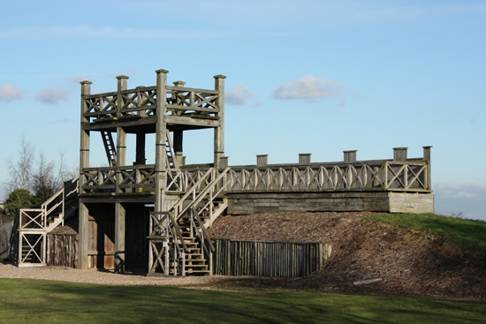
Reconstructed Timber Gate of the Lunt Fort
Roman Fort at
Baginton, Coventry, West Midlands
G.M. Sherring-Lucas /
Warwickshire County Council
|
Roman Governor of Britain
Publius Petronius Turpilianus (61/62-63) |
|
Roman Governor of Britain
Marcus Trebellius Maximus (63-69) |
|
Roman Emperor
Galba (68-69) |
|
Roman Emperor
Vitellius (69) |
|
Roman Governor of Britain
Marcus Vettius Bolanus (69-71) |
|
Roman Emperor
Vespasian (69-79) |
69
The Brigantes tribe, led by Venutius, oust their pro-Roman Queen
Cartimandua. Venutius not only rebels against his queen, she was
also his ex-wife. In fact, her divorcing him was the
final straw that led to this insurrection.
Governor Marcus Vettius Bolanus has to rescue Cartimandua from the mob.
|
Roman Governor of Britain
Quintus Petillius Cerialis (71-73) |
71
Cerialis has more troops at his disposal than did his predecessor
Marcus Vettius Bolanus. He takes advantage of this, moves swiftly, subdues the
Brigantes tribe, and builds a fortress at
Eboracum
or Eburacum (York).
|
Roman Governor of Britain
Sextus Julius Frontinus (73-77) |
74
Frontinus builds a fortress at Caerleon.
76
The Romans pick Deva (Chester)
to become one of their main strongholds.
77
By the end of his governorship, Frontinus has defeated the strong
Silures tribe of southern Wales. He
has also fought the Ordovices of northern Wales with much success, but failed to conquer the tribe
completely.
7 8
Agricola conquers the island of Mona (today's Isle of Anglesey) and
finishes the conquest of Wales (the Ordivices) and northern England,
including the Brigantes.
79 Thirty-five years after landing in
England, the Romans march into Scotland. The new Roman frontier
is a line between the Firth of Clyde and the Firth of Forth.
|
Roman Emperor
Titus (79-81) |
80
The amphitheater at Isca Silurium
(Caerleon) is completed.
|
Roman Emperor
Domitian (81-96) |
83
The Romans cross the Forth River. After subduing the Lowlands,
Agricola aims for the Highlands.
83 or 84
Battle of Mons Graupius. Roman victory over the Caledonians.
This is the first recorded battle on Scottish soil. The
battle takes place somewhere in the coastal plain of north-east
Scotland, but the exact location is unknown. Agricola wins an
important victory.
The Romans establish the
Gask Ridge
frontier along the Grampian Mountains, also called the Highland
Line, as their first northern frontier. See also
What Was the Northernmost Point the Romans
Reached?
Muir o' Fauld Roman Signal Station is set up, a Roman
watch tower on the Gask Ridge.
Around this time, the Romans commence
the construction of Inchtuthil on the
River Tay, in today's Perthshire, west of Dundee and 10 miles north
of Perth. This will be the Roman's northernmost legionary fortress.
As opposed to smaller sized and temporary forts, a legionary
fortress covers around 20 hectares / 50 acres. This is 10 times the
size of the London Olympic stadium.
Inchtuthil will also be the
fort that the Romans will occupy for the shortest amount of time. After just a
few years, Inchtuthil will be demolished and evacuated even before
the temporary quarters of the commanding officer could be replaced
by a fitting permanent version.
Agricola is recalled to Rome, receives great honors, and retires.
|
Roman Governor of Britain
Sallustius Lucullus (84-96) |
85
Around this time the fort at Ardoch
is set up.
Ardoch is located next to today's Braco, Perthshire, Scotland, UK.
Roman Fort at
Ardoch
At the time, the fort was surrounded by many temporary camps. No
stones remain, but apparently, this is the best preserved Roman earthwork
in the Roman Empire.
Google Map
Also around this time, the fort at
Stracathro is built. This will be the
northernmost Roman post for a while.
87
The Roman Empire is threatened on other frontiers in mainland
Europe, esp. on the Danube River. Roman forward movement into Scotland
comes to a standstill, then they draw back. The Romans evacuate their fortress at Inchtuthil. The Highlands
are left to be conquered another
day.
90
All forts north of the Earn River are evacuated. The Romans will
withdraw all the way back to the Tyne-Solway line.
|
Roman Emperor
Nerva (96-98) |
|
Roman Governor of Britain
Publius Metilius Nepos (96-?97) |
|
Roman Governor of Britain
Tiberius Avidius Quietus (?97-?100) |
|
Roman Emperor
Trajan (98-117) |
|
Roman Governor of Britain
Lucius Neratius Marcellus (?100-103) |
|
Roman Governor of Britain
Marcus Appius Bradua (?115-118) |
|
Roman Emperor
Hadrian (117-138) |
This map shows Hadrian's Roman Empire in 117, illustrating its extension,
legion headquarters in Britannia at Eboracum (York),
Deva
(Chester), Isca (Caerleon), Roman roads, and fortified frontiers.
AD 117 Roman Empire (USMA)
|
Roman Governor of Britain
Quintus Pompeius Falco (118-122) |
|
Roman Governor of Britain
Aulus Platorius Nepos (122-?125) |
122-128 The Romans build
Hadrian's Wall,
a permanent northern frontier of Roman Britain that is 73 miles or
118 kilometers long, 15 feet high, and built of stone.
It runs
between the Rivers Tyne in the east and Solway Firth in the west.
Building of the wall takes 6 years.
Here are the maps:
AD 122 Limes in
Britain, Hadrian's Wall
Illustrating Hadrian's Wall and Roman Camps in Britannia
Click to enlarge
Map of Hadrian's Wall
Click to enlarge
In charge of the construction work is the former governor of Lower
Germany, Aulus Platorius Nepos. In July 122, he was transferred to Britain.
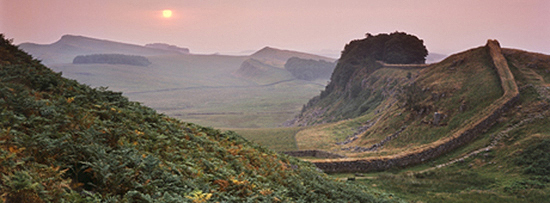
Hadrian's Wall
English Heritage Foundation
Hadrian's Wall
BBC Scotland
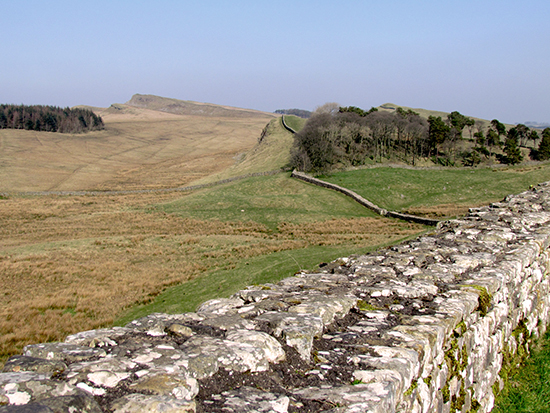
Hadrian's Wall, Northumberland,
England
National Education Network
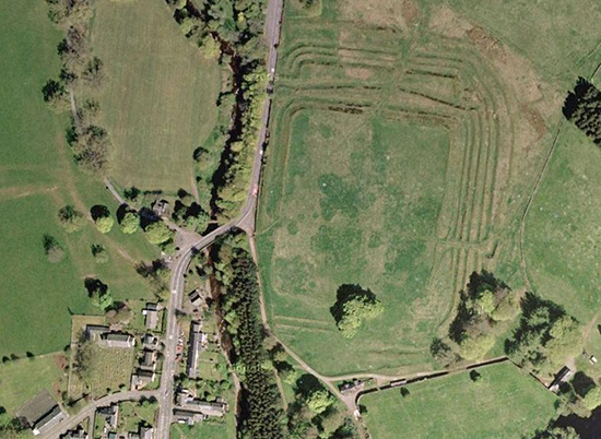
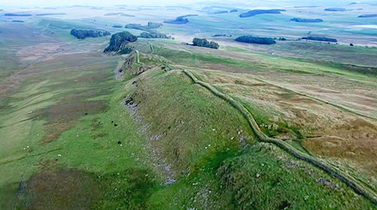
Housesteads Fort was one of the
Roman outposts along Hadrian's Wall:
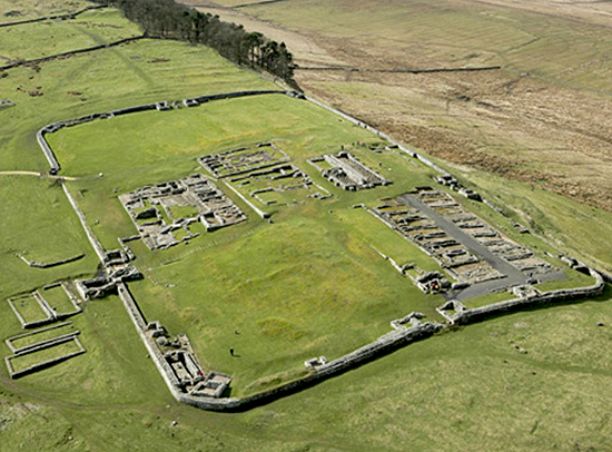
Aerial View of Housesteads Roman
Fort / Hadrian's Wall
English Heritage Foundation
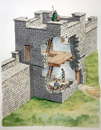
Banks East Turret,
Hadrian's Wall
Cutaway reconstruction drawing
by Philip Corke
|
Roman Emperor
Antoninus Pius (138-161) |
|
Roman Governor of Britain
Quintus Lollius Urbicus (139-142 or
143) |
142
Under
Antoninus Pius, the Romans push further
north once again, abandoning Hadrian's Wall. They return to Perthshire
and rebuild
some of their former forts, Ardoch for example. They also build a new wall
some 100 miles north of
Hadrian's Wall, the
Antonine
Wall. In charge is Quintus Lollius
Urbicus.
The wall is made out of turf and timber and runs 37 miles or 59
kilometers long. It stretches coast-to-coast and connects today's
Bo'ness on the Firth of Forth in the east with
Old Kilpatrick on the Firth of Clyde in the west.
This wall
marks the farthest extent of Roman occupation in ancient
Britain, and is therefore also called Rome's
Final Frontier.
Here is the map:
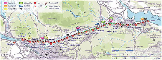
Map of the Antonine Wall, Its Forts, Fortlets, etc.
Click to enlarge
14 4
Construction of the Antonine Wall is finished.
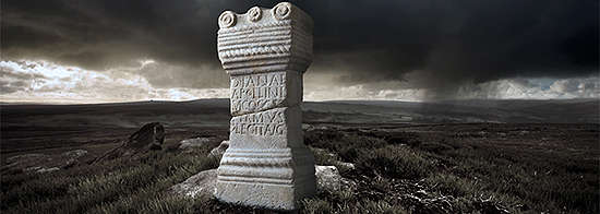
Distance Slab from the Antonine Wall
National
Museums Scotland
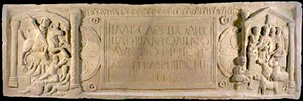
Altar to Diana and Apollo, Antonine Wall
It reads: DIANAE APOLLINI M COCCE(I) FIRMVS > LEG II AVG
In other words: For Diana and Apollo, Marcus Cocceius Firmus,
centurion of the Second Augustan Legion.
Altar stone made of sandstone, 0.72 x 0.31 x 0.22 m
From the Auchendavy Roman Fort and Settlement,
3 kilometers east of Kirkintilloch, on the Antonine Wall
University of Glasgow
The Antonine Wall is well fortified. A field of defense pits filled with sharp wooden stakes, hidden with
branches and covered with foliage, was created in front of a massive ditch, 9 meters
(30 feet) across, 4 meters (13 feet) deep, filled with thorn
branches, followed by a nearly vertical wall, 4 meters (13 feet) high,
with palisades on top of the wall and Roman soldiers behind them.
Here is a sketch:
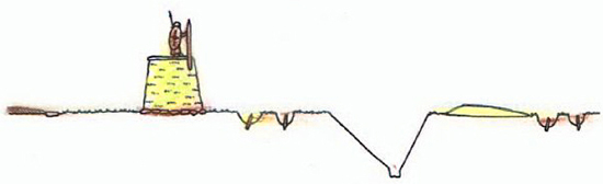
Drawing of the
Defense System at the Antonine
Wall
Historic Scotland
And here are the defense pits at Rough Castle:
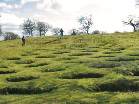
Roman Defense Pits, Rough Castle, Antonine Wall
RCAHMS
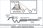
See also
Roman Field Fortifications
158
The Romans have pushed all the way up north to Bertha. But now the
forward movement comes to a halt because Roman troops are again needed
elsewhere in the Empire. They begin to retreat.
|
Roman Emperor
Marcus Aurelius (161-180) |
167
The Antonine Wall is abandoned a little more than 20 years
after its construction.
The Romans withdraw back to their former frontier, Hadrian's Wall.
|
Roman Emperor
Commodus (180-192) |
190s
Coin hoards at Birnie, 40 miles east of
Inverness.
Here is the picture.
|
Roman Governor of Britain
Decimus Clodius Albinus (191-197) |
|
Roman Emperor
Pertinax (January - March 193) |
|
Roman Emperor
Didius Severus Julianus (March 28 –
June 1, 193) |
|
Roman Emperor
Septimius Severus (193-211) |
208
Roman Emperor Severus commences the third and last major Roman invasion
into today's Scotland. He is ready to conquer Caledonia once and for all.
211
Severus dies at York. This concludes his campaign in Scotland.
|
Roman Emperor
Caracalla (211-217) |
Caracalla, instead of continuing his father's Scotland campaign,
makes peace with the natives and returns to Rome.
212 Caracalla grants Roman
citizenship to all free inhabitants of the empire. This is the
Edict of Caracalla.
213
Around 213, Britain is divided into two provinces,
Britannia Superior (capital:
Londinium / London) and Britannia Inferior
(capital: Eboracum / York).
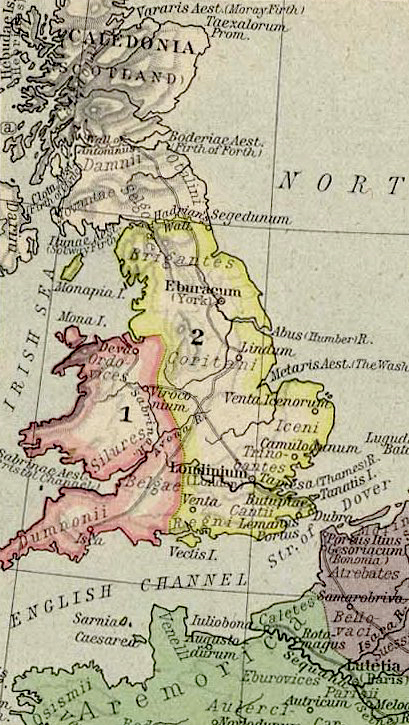
Upper
Britain, Lower Britain, and
Caledonia (Scotland)
Click to enlarge
Also illustrating: Hebudae (Hebrides),
Vararis Aestuarium (Moray
Firth), Taexalorum Promontorium,
Clota Aestuarium (Clyde Firth),
Bodotria Aestuarium (Forth Firth),
Itunae Aestuarium (Solway Firth),
Segedunum (Wallsend),
Monapia (Isle of Man),
Mona (Anglesey),
Abus
(Humber), Metaris Aestuarium (The Wash),
Sabrinae Aestuarium
(Bristol Channel), Vectis (Isle of Wight),
Tamesa (Thames)
|
Roman Emperor
Macrinus (217-218) |
|
Roman Emperor
Elagabalus (218-222) |
|
Roman Emperor
Alexander Severus (222-235) |
|
Roman Emperor
Maximinus (235-238) |
|
Roman Emperor
Gordian I (March - April 238)
jointly with his son
Gordian II |
|
Roman Emperor
Pupienus Maximus (238) jointly with
Balbinus |
|
Roman Emperor
Gordian III (238-244) |
|
Roman Emperor
Philip (244-249) |
|
Roman Emperor
Decius (249-251) |
|
Roman Emperor
Hostilian (251) |
|
Roman Emperor
Gallus (251-253) |
|
Roman Emperor
Aemilian (253) |
|
Roman Emperor
Valerian (253-260) |
|
Roman Emperor
Gallienus (253-268) |
|
Roman Emperor
Claudius Gothicus (268-270) |
|
Roman Emperor
Quintillus (269-270) |
|
Roman Emperor
Aurelian (270-275) |
|
Roman Emperor
Tacitus (275-276) |
|
Roman Emperor
Florian (276) |
|
Roman Emperor
Probus (276-282) |
|
Roman Emperor
Carus (282-283) |
|
Roman Emperor
Carinus (283-285) |
|
Roman Emperor
Maximian (286-305) |
297 First written record of
the
Picti (Picts) by a Roman writer who
describes the people living in Scotland / or north of Hadrian's
Wall.
|
Roman Emperor
Constantius I Chlorus (305-306) |
|
Roman Emperor
Severus (306-307) |
|
Roman Emperor
Maxentius (306-312) |
|
Roman Emperor
Constantine I (312-337) |
|
Roman Emperor
Constantine II (337-340) |
|
Roman Emperor
Constans I (337-350) |
|
Roman Emperor
Constantius II (337-361) |
|
Roman Emperor
Julian (361-363) |
|
Roman Emperor
Jovian (363-364) |
|
Roman Emperor
Valentinian I (364-375) |
367/368 The
Picts push the
Romans back from Hadrian's Wall.
|
Roman Emperor
Gratian (367-383) |
|
Roman Emperor
Valentinian II (375-392) |
|
Roman Emperor
Theodosius I (392-395) |
|
Roman Emperor
Honorius (395-423) |
395 The Roman Empire splits
permanently into East and West.
410
Emperor Honorius receives a request for military aid from Britannia. His answer is a
negative. This reply is also known as the
Honorian Rescript. The exact role that this decree plays
in the closing stages of Roman Britain is debated.
In any event, by the year 411 Rome was unable to enforce its
control in Britain.
On August 24, 410, the
Visigoths, led by
Alaric, enter Rome. They will loot
the city for three
days.
Here are the maps illustrating the situation in Britain at the end of the
Roman occupation:
400 Roman
Britain
Click to enlarge
410 Roman Britain
Click to enlarge
See also
Governments of Rome.
And maybe
Roman Empire.
And More Maps

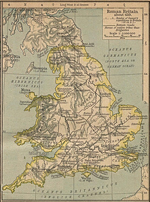
Map of Roman Britain
Illustrating: coloniae and principal centers, other populated
centers,
fortresses and forts, mines, frontier walls, roads
Further illustrating: Antonine Wall,
Hadrian's Wall, Firth of Clyde,
Firth of Forth, Ireland, Solway Firth, Tyne, Isle of Man, Irish Sea,
Isle of Anglesey, North Sea, The Pennines, Catterick (Cataractonium),
York (Eboracum), Humber, Derbyshire, Lincoln (Lindum), Flintshire,
Chester (Deva), Fosse Way, Severn, Leicester (Ratae Coritanorum),
The Wash, Cirencester (Corinium), Gloucester (Glevum), Caerleon (Isca
Silurum),
Cotswold Hills, Oxford, Thames, Colchester (Camulodunum), St. Albans
(Verulamium), London (Londinium), Rochester (Durobrivae),
Lullingstone, Medway, Canterbury (Durovernum), Richborough (Rutupiae),
Chichester (Noviomagus Regnensium), Isle of Wight, Hinton St. Mary,
Mendip, Bristol Channel, Exeter (Isca
Dumnoniorum), English Channel, Gaul
Encyclopaedia Britannica
One of the main Roman roads was
Fosse Way, connecting Exeter
and Lincoln. In fact,
Fosse Way marked one of the earliest
Roman frontiers even before AD 47.
Map of
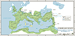
Britain — Imperial Province, Rome's Expansion 264 BC - AD 180
Click to enlarge
The Roman Army
Composition, organization, and
formation of the Roman military changed over time. But for the sake
of a quick mental grasp, let's say that,
|
 |
A
centuria
comprised 80 to 100 troops. Their leader was
the centurion.
A
cohort
comprised 400 to 500 troops. Five to six
centuriae made a cohort.
A
legion
comprised 5,000 to 6,000 troops. Ten cohorts,
or sixty centuriae, made a legion.
|
For the native eye, marching Roman soldiers
must have been quite
impressive. When 20,000 troops were on the move, for example, their entire convoy
could be 5 miles long.
Not all Roman soldiers came from the
motherland. In fact, many had never seen Rome.
The Roman Empire recruited men from all its conquered territories.
Thus, Roman soldiers who fought in Scotland, for instance, could very
well be natives of North Africa, Belgium, England, or France.
Main Roman Towns in
Ancient Britain A-Z
Calleva Atrebatum
(Silchester in Hampshire)
Camulodunum
(Colchester in Essex)
Corinium Dobunnorum
(Cirencester in Gloucestershire)
Deva
(Chester in Cheshire)
Permanent legionary base
Durnovaria
(Dorchester in Dorset)
Durovernum
Cantiacorum (Canterbury in Kent)
Eboracum
(York in North Yorkshire)
Permanent legionary base
Isca Dumnoniorum
(Exeter in Devon)
Isca Silurium
(Caerleon in Gwent)
Permanent legionary base
Isurium Brigantum
(Aldborough in North Yorkshire)
Lindinis
(Ilchester in Somerset)
Lindum Colonia
(Lincoln in Lincolnshire)
Londinium
(London)
Luguvalium
(Carlisle in Cumbria)
Moridunum
(Camarthen, exact location unknown)
Nervia Glevensium
(Gloucester in Gloucestershire)
Noviomagus
Regensium (Chichester in West
Sussex)
Ratae Coritanorum
(Leicester in Leicestershire)
Venta Belgarum
(Winchester in Hampshire)
Venta Silurum
(Cearwent in Gwent)
Verulamium
(Saint Albans in Hertfordshire)
Viroconium
Cornoviorum (Wroxeter in
Shropshire)
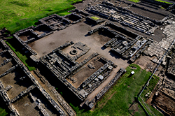
Roman Ruins
Traces and archaeological remains from
365 years of Roman occupation are abundant. There are over 125 known forts,
many fortlets, and mile castles or signal posts. Very often, the
military presence encouraged civilian settlements in the immediate
neighborhood.
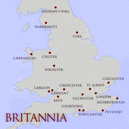
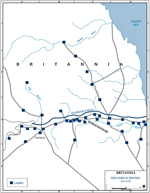
Map of Britannia -
Principal Roman Sites in Ancient Britain
Illustrating: Hadrian's Wall,
Hardknott, York, Caernarfon, Chester, Wroxeter, Caerleon, Caerwent,
Cirencester, St. Albans, Colchester, Bath, Silchester, London,
Richborough, Fishbourne, Portchester, Pevensey
See more from
James Eason
|
 |
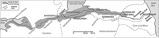
You can visit the
Roman Army Museum, located at
Greenhead, at the site of Carvoran Roman Fort on Hadrian's Wall. |
|
Just a tad to the east of Greenhead
are the remnants of the
Roman military post
Vindolanda. |
 |
One car hour southeast of Edinburgh,
or 15 km / 9 miles south of Jedburgh, you will find
Pennymuir Camps, linear
earthwork outlining Roman marching camps, or temporary camps.
Pennymuir Camps were a pit stop on
Dere Street, a Roman road that
connected Eboracum (York) with the northern border of the Empire.
|
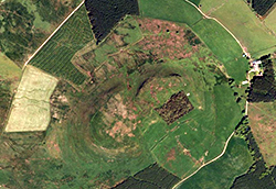 |
Two miles southeast of Lockerbie you
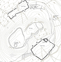
will find Burnswark Hill, which was the location of a large native
hill fort.
This hill fort was sandwiched by two military encampments or siege
camps.
Image: Google |
|
It is disputed whether or not the hill fort had been
abandoned by the time the Roman siege forts were set up.
Depending on that answer, Burnswark
Hill was either used as practice or training grounds for Roman soldiers,
or this was the real deal and a wicked siege took place at this
address. Some called it Scotland's own Massada.
Either way, this is a remarkable site.
Image: RCAHMS |
 |
|
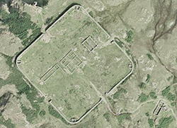 |
Hardknott Roman Fort is located in the
beautiful Cumbrian Mountains. It was founded under Emperor Hadrian.
Remains of the headquarters building,
the commandant's house and the bath house can be visited. And 218
yards / 200 meters to the east lies the parade-ground.
Image: Google |
Roman Britain — Literary Sources
Julius Caesar
lived 100-44 BC
Caesar wrote
On the Gallic War
(De Bello Gallico).
For the section on Britain see Book IV,
chapter 20 to Book V, chapter 23.
Tacitus lived 56-120.
He was the
son-in-law of Gnaeus Julius Agricola, a Roman general
who served as governor of Britain
from 78-84. Tacitus wrote Agricola's biography,
De vita Julii
Agricolae, his first published work.
Suetonius lived 69-after 122
Here is the English translation of
The Lives of the Twelve Caesars
by Gaius Suetonius Tranquillus, provided by Gutenberg. Suetonius, by
the way, had a knack for gossip and knew how to report it with great
skill.
Dio Cassius lived 150-235
Dio Cassius,
or Dio Cocceianus, wrote in Greek. Here you
can read the English translation of
Dio's Rome in 6
volumes.
What Came Next in
British History?
The Angles, Saxons, Jutes, and Frisians
kept on coming. This immigration of the Anglo-Saxons overlapped with
the departure of the Romans.
Here is a map of Kent:
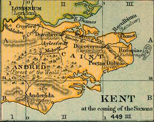
Map of Kent at the coming of the Saxons, 449
Click to enlarge
And with regards to later migration see this map:
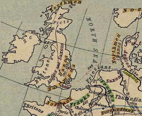
Map of the Germanic
Migrations and Conquests,
150-1066
Illustrating:
Scots, Northmen, Picts, Britons, Angles and
Saxons, Danes, Normans, Jutes,
Vinland (Leif Eriksson's America) 1000,
Greenland 982, Iceland 867
Click to
enlarge
British Archaeology
To put Roman Britain into context,
here are the dating periods in British archaeology:
|
Prehistoric
|
| |
|
|
Mesolithic |
10,000
- 3,500 BC |
| |
|
|
Neolithic |
3,500
- 2,000 BC |
| |
|
|
Stonehenge, by the way, was built in
six stages between 3000 and 1520 BC.
|
| |
|
|
Bronze
Age |
2,000
- 700 BC |
| |
|
|
Iron
Age |
700 BC
- AD 43 |
| |
|
|
|
|
|
Historic
|
| |
|
|
Romano-British |
AD 43
- 410 |
| |
|
|
Early
Medieval
(Saxons, Vikings) |
410 -
1066 |
| |
|
|
Medieval (Normans) |
1066 -
1540 |
| |
|
|
Early
Post-Medieval |
1540 -
1700 |
| |
|
|
Post-Medieval (agricultural,
industrial revolutions) |
1700 -
1900 |
| |
|
|
Modern |
1900 -
today |
As ancient describes the historian what refers to the
time period from the beginning of civilization
until the fall of the Western Roman Empire in AD
476.
Hence, Roman
Britain is the last chapter in the history of Ancient
Britain.
See also
Archaeology in the History Dictionary.
More History
|